
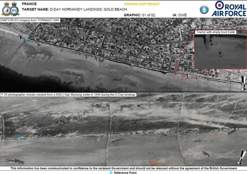
RAF reconnaissance planes have taken shots of the D-Day beaches after 70 years. With today’s stand-off technology and higher resolutions.
RAF Tornado GR4 jets from II (AC – Army Co-operation) Squadron from RAF Marham have used today’s technology to emulate their World War II counterparts that, on D-Day, Jun. 6, 1944, took the first pictures of the Normandy landings.
The two Tornados flew at 400 mph and 20,000 feet over Gold, Juno, Utah and Sword beaches, replicating the images the same squadron and their Mustang brought back during the 36 reconnaissance sorties flown on D-Day.
70 years ago, II (AC) Squadron used bulky cameras loaded onto the bottom of the Mustangs to get panoramic images of the beaches. Today, a single Tornado sortie provides much better results using the RAPTOR (Reconnaissance Airborne Pod for Tornado) which takes aerial images and the Litening III Advanced Targeting Pod that is able to capture Full motion video.
Here’s the comparison between the quality of images taken today as compared to those of 1944.
Image credit: Crown Copyright
Related articles


