The United States intensified its ISR (Intelligence Surveillance Reconnaissance) presence in the Black Sea after Kerch Strait incident. Here’s an analysis.
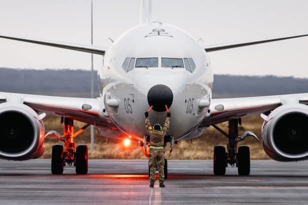
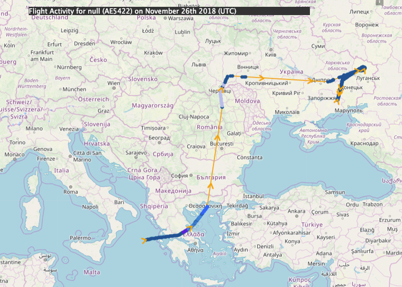
Following the incident in the Kerch Strait near Crimea in the morning of Nov. 25, 2018, the United States has increased the presence of its airborne assets in the area. In the days following the incident, a variety of ISR aircraft from both the U.S. Air Force (USAF) and Navy (USN) were dispatched to the area to monitor the situation on the ground and the movement of personnel and equipment. More specifically, the US used its maritime surveillance aircraft P-8A Poseidon and RQ-4 Global Hawk UAS (Unmanned Aerial System) from Naval Air Station Sigonella (Sicily, Italy) along with a RC-135 Rivet Joint and EP-3E ARIES II electronic reconnaissance aircraft, both based at Souda Bay (Crete, Greece).
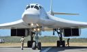
As reported before, Russia sent Su-25 attack aircraft and Ka-52 combat helicopters to the Crimean Bridge following the incident in the Kerch Strait. At that time, no other aircraft were known to be in the area to monitor the situation (although US spyplanes routinely operate over the Black Sea – with their transponders turned on – where they are also intercepted by Russian aircraft). However, beginning on Nov. 26, the USAF has maintained a significant presence in the Black Sea and Crimea area.
As done in April 2018, when an OSINT analysis based on ADS-B, Mode-S, MLAT, radio comms, etc., allowed us to get a pretty good idea of what was happening during the first wave of air strikes on Syria, well before anyone else, the following analysis is based on a variety of (public domain) sources and estimates based on time, speed and position. As usual, it also leverage on the contribution of several people on Twitter, FB, IG, forums and various other social or private networks, who have provided additional details, logs and hints.
Here below you can find all the U.S. ISR flights identified in the area from Nov. 26 to Dec. 5.
| Date | Callsign | Type | Registration | Origin | Destination |
| 26-11-2018 | FORTE10 | Q4 | 11-2047 | LICZ | LICZ |
| 26-11-2018 | JONAS21 | R135 | 64-14841 | LGSA | LGSA |
| 26-11-2018 | PS266 | P8 | 168764 | LICZ | LICZ |
| 27-11-2018 | FORTE10 | Q4 | 11-2047 | LICZ | LICZ |
| 27-11-2018 | PS276 | P8 | 168848 | LICZ | LICZ |
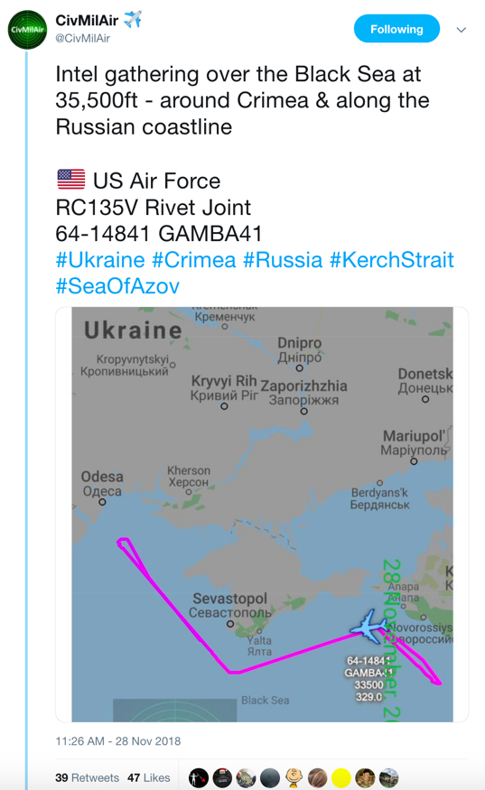
| 28-11-2018 | GAMBA41 | R135 | 64-14841 | LGSA | LGSA |
| 30-11-2018 | DAVID61 | R135 | 64-14841 | LGSA | LGSA |
| 30-11-2018 | PS306 | P8 | 168764 | LICZ | LICZ |
| 01-12-2018 | FORTE10 | Q4 | 11-2048 | LICZ | LICZ |
| 01-12-2018 | PS016 | P8 | 168859 | LICZ | LICZ |
| 02-12-2018 | FORTE10 | Q4 | 11-2048 | LICZ | LICZ |
| 02-12-2018 | PS026 | P8 | 169438 | LICZ | LICZ |
| 02-12-2018 | FORTE10 | Q4 | LICZ | LICZ | |
| 03-12-2018 | VETCH21 | R135 | 64-14841 | LGSA | LGSA |
| 03-12-2018 | PS036 | P8 | 168324 | LICZ | LICZ |
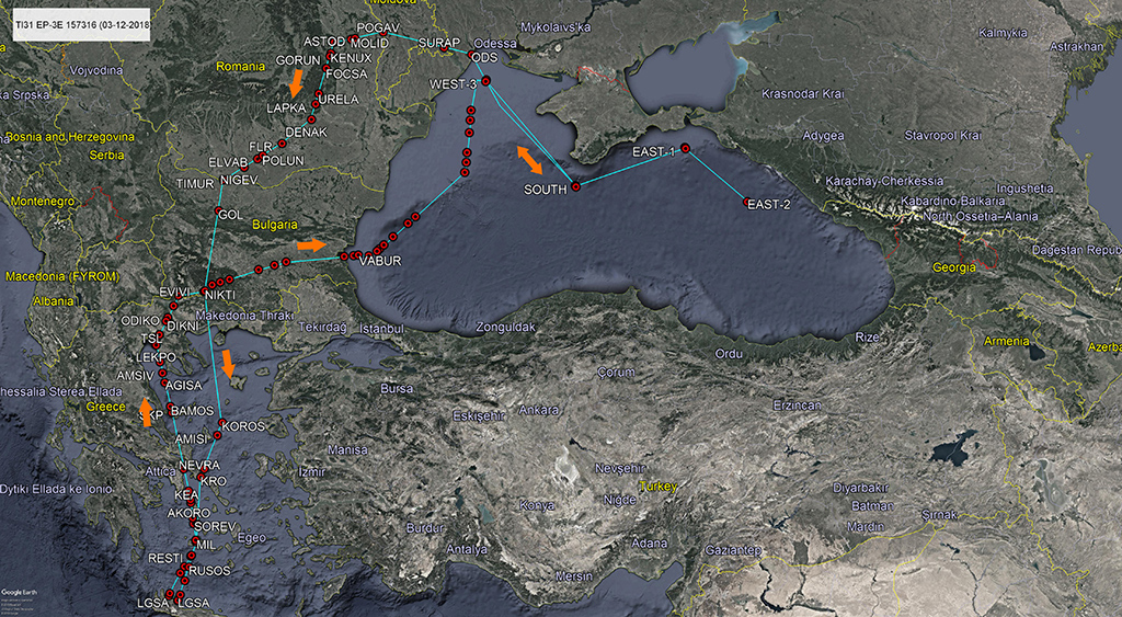
| 03-12-2018 | TI31 | P3 | 157316 | LGSA | LGSA |
| 04-12-2018 | FORTE10 | Q4 | 11-2048 | LICZ | LICZ |
| 04-12-2018 | PS046 | P8 | 168848 | LICZ | LICZ |
This list highlights the variety of movements and airborne assets that were dispatched to the area. It should be noted that most of these flights, predominantly the RQ-4 flights, had a repetitive character in the days that followed in terms of routing.
Routes
By international law, a country’s sovereign airspace corresponds with an area as far as 12 nautical miles (22.2 km) out from a nation’s coastline. In the absence of fixed airways and waypoints, the aircraft use a variety of frequently used user-defined points to navigate through the area. These routes (that assure that the aircraft are flying in international airspace at all times.
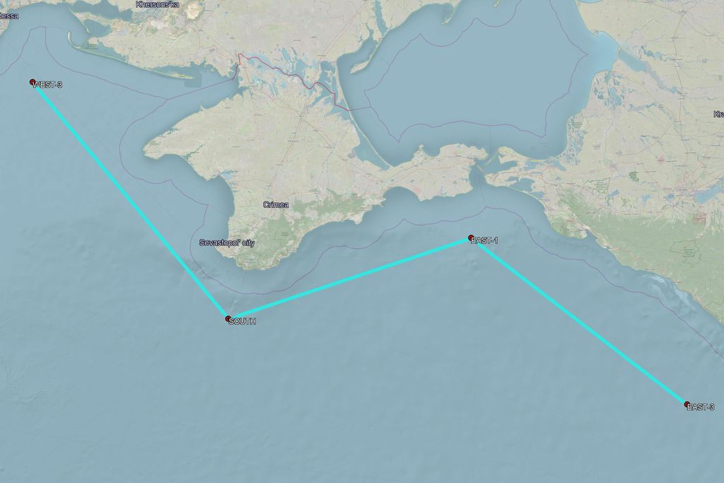
The main track that can be deduced by studying the movements of the U.S. spyplanes, covers the entire area around the southern part of Crimea and is approximately 450 nautical miles in length and in a form that provides the ability the monitor the entire area from different angles. All aircraft that were confirmed to be in the area made (partially) use of this track. For the purpose of this analyses, the route has been simplified and the waypoints outlining it have been designated as WEST, SOUTH and EAST.
In the night between Nov. 25 and 26, the USAF launched a Sigonella-based RQ-4 UAV as FORTE10. After departure (shortly after 02.00AM LT) the aircraft went on a northbound track to eventually enter the western part of Ukraine via waypoint NUKOV, that it reached around 05.30AM LT. The UAV entered the Black Sea area via waypoint KOSAK around 12.00PM. It took the above mentioned track along the western, southern and eastern part of Crimea and continued all the way down to the area adjacent to Sochi (Krasnodar Krai district). During the entire afternoon, it made several passes while maintaining an altitude of 53,000 feet. It left the area via waypoint INKOM just before 18.00 LT totaling almost 8 hours of continued surveillance. FORTE10 transitioned via Bulgaria and Greece back to Sigonella via the same route as it went northbound, completing a 21-hour flight.
By interpolating the Mode-S tracks collected by various receivers and the waypoints reached by the aircraft (also based on the LiveATC radio comms), we can get a quite clear idea of the route followed by Forte 10.


While FORTE10 was flying north, over at Souda Bay, a RC-135 Rivet Joint with callsign JONAS21 departed around 05.00AM on a Black Sea mission. After departure, it flew directly north, overhead Thessaloniki (TSL), before entering the Bulgarian airspace. At waypoint GOL, an easterly heading was maintained as it entered the Black Sea via waypoint INKOM at around 06.50AM LT.
A review of all the routes used by these aircraft shows that this particular waypoint is the common entry and exit point of the area. Although the “Bulgarian route” is a significant diversion from the most direct route to the Black Sea, it presumably serves one main goal: to avoid the Turkish airspace.
Despite this route, the RC-135V was the first US airborne asset to be on scene since FORTE10 was patrolling overhead Ukraine. In a similar fashion, JONAS21 made several passes along the track and some intermediate holding patterns, mainly along the western part of Crimea. The aircraft maintained an altitude of 31500 feet. It left the area around 15.05LT making it just over eight hours of ‘on-station’ time.

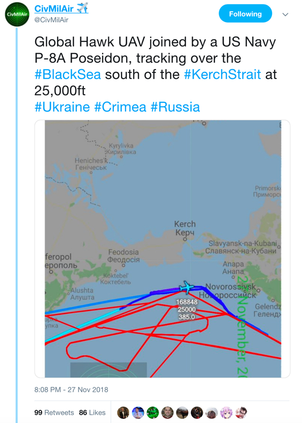
While the RC-135V was on station, over at NAS Sigonella, a USN Boeing P-8A Poseidon departed as “PS266” before 12.00PM. The aircraft set course towards Greece where it followed the same routing as JONAS21 before entering the Black Sea shortly after 13.00LT. Although there are no records of its movements near Crimea, it left the area again at 18:09 hrs. on its return to Sigonella.

The next day, Tuesday, Nov. 27, two flights were tasked to provide some intel on Crimea. FORTE 10 (USAF RQ-4s belonging to the 7th Reconnaissance Squadron of the 69th Reconnaissance Group almost always fly with the same callsign) once again departed from Sigonella under the cover of darkness just before 03.30AM LT. Similar to the flight on Nov. 26, it also made its way towards the western part of Ukraine, transitioning via Greece, Bulgaria and Romania. It spent several hours patrolling above the Ukraine at 51,000 ft. This time however, it was spotted in the afternoon above the far eastern part of Ukraine. It made it further east before going westbound, providing the opportunity to closely monitor the northern border or Crimea. Following this, it again made its way to the northern part of the Black Sea to establish surveillance on Crimea before 16.00LT. There, it once again flew the usual track for a period of well over 4 hours before heading home.

The flight was closely tracked online on Twitter:
🇺🇸 US Air Force RQ-4 Global Hawk
52,000ft over the Black Sea – around Crimea, past the Kerch Strait & along the Russian coastline#Crimea #Ukraine #Russia #KerchStrait pic.twitter.com/rsX1Ap0zAV
— CivMilAir ✈ (@CivMilAir) November 27, 2018
In the afternoon, a US Navy Boeing P-8A Poseidon was also once again dispatched to the Black Sea. PS276 left Sigonella, flew towards Bulgaria before entering the area of interest around 17.30LT. Its trajectory also included a short pattern just due south of the Kerch Strait. Remarkably, PS276 was the first aircraft to apparently move in quite close to the territorial border. It was spotted making a continuous right turn to the area to the west of Sevastopol before making a hard left hand turn towards the south-west. During these maneuvers, it just remained in international airspace. The pilots climbed and descended on multiple occasions between 30,000 and 34,000ft. PS276 left the Black Sea again around 20.00LT, returning towards its base.

🇺🇸 USAF RQ-4 Global Hawk – 52,000ft over Greece, heading back to NAS Sigonella, Sicily pic.twitter.com/JzpTkezmgX
— CivMilAir ✈ (@CivMilAir) November 27, 2018
In the following days, a variety of aircraft were sent to the area for the continuation of surveillance and intelligence gathering.
On Monday Dec. 3, an EP-3E ARIES II was dispatched for the first time to the area since the beginning of the naval blockade. It departed Souda Bay around 06.30LT as “TI34”. After the usual route through Greece and Bulgaria, the aircraft entered the Black Sea area at around 08.40LT. Initially, a northerly course was maintained parallel to the shore line. However, it reached the norther end of the race track at 08:40 hrs. after which it began to move towards southern Crimea, eventually making it to the eastern end of the line. Subsequently, “TI34” continued on north-westerly heading while routing back to Souda Bay via Moldova and Romania before starting RTB (return to base).
Further analysis of the timing and duration of the different aircraft seen near Crimea reveals that their presence was predominately during the afternoon. In the day following the incident, during a few hours at the beginning of the afternoon, a total of three aircraft were in the area. Despite its very long endurance, RQ-4 “FORTE10” only flew near Crimea for 5 hours (most probably because it was mainly tasked with providing surveillance capabilities over Ukraine). Its long range capabilities allowed RC-135V “JONAS 21” to be ‘on-station’ for a significant amount of time (around 9 hours). The P-8A PS266 got about equally as much time on station as “FORTE 10”.
Equipment and Personnel
The additional interest in the area is understandable given the fact that a few days after the incident, Russia announced it would deploy an additional S-400 surface-to-air missile systems, next to the current number of three systems already present. A representative of the Southern Military District told Interfax on Wednesday Nov. 28 that it would be deployed to “protect the airspace of the Russian Federation.” Eventually, the system was deployed on Nov. 29 at Dzhankoy Airbase in northern Crimea. Satellite imagery provided by ImageSat confirmed that several launchers were located at Dzhankoy.
Tension in the Crimea: #Russia has deployed S-400 at Dzhankoy Airbase.
After the sea incident in the #Azov Sea, the #Russians are setting up another S-400 battery in #Crimea peninsula and thickening the #military forces around #Ukraine. pic.twitter.com/hwY2AEScff
— ImageSat Intl. (@ImageSatIntl) December 2, 2018
Earlier, a Bal-E coastal anti-ship missile systems was spotted both on Nov. 27 and 28 while being moved towards the entrance of the Kerch Strait.
Russian Air Force
Interestingly, the Russian Airforce (RuAF) sent a total of five of its IL-76 transport aircraft to Crimea. In the afternoon of Dec. 5, aircraft RF-76740, RF-76743, RF-76747 RF-76739 initially flew from Taganrog Tsentralny Air Base to Anapa Airport (URKA). The next day, the entire ‘convoy’ headed towards Dzhankoy Airbase in Crimea. RF-76549 was later seen to be also going towards Crimea. Moreover, a RuAF A-50 AWACS aircraft was seen arriving at Novofedorivka (UKFI) in western Crimea, origination from Ivanovo Severny Air Base.
Ил-76 А-50 50606 Иваново – Саки #RF50606 #RuaF pic.twitter.com/JDFrzge9kD
— Записки охотника (@galandecZP) December 7, 2018
Two of them, RF-76747 and RF-76739, were seen heading back towards Anapa on Dec. 8. Additionally, a large convoy of military equipment from a VDV division of airborne troops, origination from Russia, was seen on the Crimea Bridge on Dec. 8. Someone suggested that the aircraft were used to transport an unknown amount of airborne assault troops into the area, together with the ground equipment.
Open Skies
To date, the United States has remained an active role in gathering intelligence in close coordination with its NATO partners.
On Dec. 6, the United States conducted an extraordinary flight under the Open Skies Treaty. A press release by the U.S Department of Defense highlighted that “the timing of this flight is intended to reaffirm U.S. commitment to Ukraine and other partner nations.” The flight was carried out by Open Skies OC-135B, registration 61-2670. Origination from Offutt AFB, it flew to Ramstein Air Base in Germany where it departed again in the morning of Dec. 5 towards Kiev. Around 09.30 GMT, OSY12F departed in a southern direction towards Crimea. At 10:20 hrs Zulu, it was captured via MLAT flying just north of Crimea flying towards the east.
Given the continued (diplomatic) tension between Russia, the Ukraine, the United States and its NATO partners, it is expected that there will a continued effort to provide surveillance and reconnaissance capabilities focused on the Crimean peninsula. Something that will raise the interest of aircraft spotters and flight trackers from all around, who will be able to “monitor” missions in real time, more or less the same way the Russians have been doing.