
We undertook a very unusual trip over Nevada desert.
Area 51, a myth in the underworld of conspiracy theories, especially for those who believe in alien spacecrafts, flying saucers, UFOs etc, is a highly classified installation in the Nevada desert.
Since the 1950s, the remote site, located south of the dry Groom Lake, has been used to support the development and testing of several aircraft and weapons systems including the famous U-2 Dragon Lady, the Mach 3+ SR-71 Blackbird, or the later F-117 stealth fighter (more precisely its Have Blue prototype).
Its involvement in Black Projects and the secrecy surrounding the operations conducted over there has made Area 51 the most interesting secret airbase in the world for aviation enthusiasts.
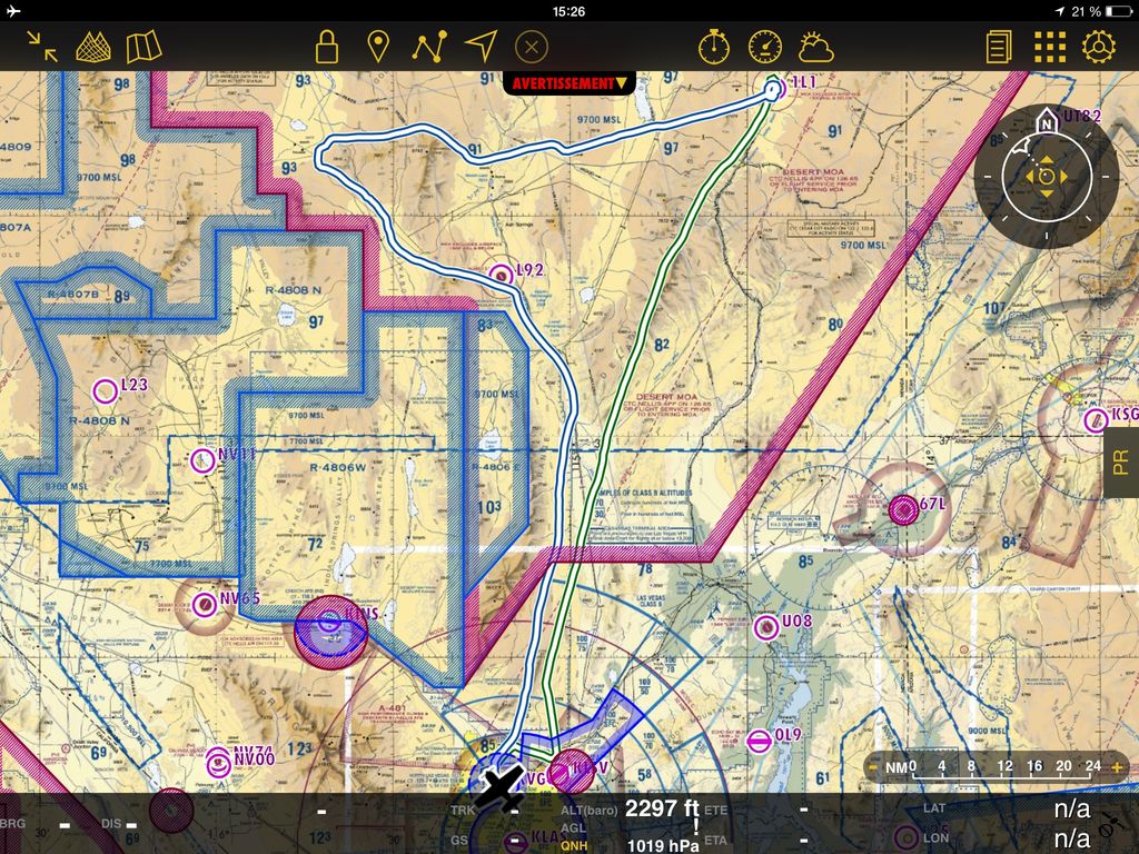
Groom Lake airbase is located inside the Nellis Test and Training Range, 200 miles north of Las Vegas, under a dedicated and forbidden airspace identified as R4808N in the aeronautical charts. This place is well protected from prying eyes as the ground perimeter extend to 10 miles from the runways, and a small ridge inside the Area prevent anyone on the Tikaboo valley to see anything.
Most enthusiasts and photographers climb Tikaboo peak. This vantage point is difficult to access, is almost 8,000 feet high which puts it 3,000 feet over the airbase but 26 miles away. You need a powerful telelens to see anything from there.
Being a very long time military aviation fan, both interested in the secret life of Groom Lake and in the larger Nellis Test and Training Range (NTTR) where every Red Flag exercise happen since the 70s, I wanted to see it in real. What made it possible is that I’m a private pilot, and the airspace east of R4808N is “just” classified as a Military Operating Area (MOA). It’s a danger area when it’s active or “hot” (meaning some military activity is scheduled or in progress), but still accessible for anyone at their own risk.
While on vacation in the area, I decided to attempt a flight there, during the weekend to lessen any risk, particularly with the Air Traffic Control (ATC) in the area. I booked a rental Cessna 172 Skyhawk at West Air Aviation in North Las Vegas airport (KVGT) and had an appointment with an instructor for a check ride.

On a Friday late afternoon, after having spent the day around Nellis AFB, taking pictures of military jets of all sorts involved in their last day of Red Flag simulated war, I met Jacob for my “flight review”. After one hour of questions/answers about air traffic rules in the US and flight safety, I climbed in the small Cessna 172 cockpit for a short flight.
The sun was really low and it was time for me to prove Jacob that I knew how to handle this wingy thing. Fortunately, I use to fly a Skyhawk at home so I behaved myself at the controls. Slow flight, steep turns and simulated loss of engine: I went through all before heading back to the airfield for pattern work.
After a couple of touch and goes, and the radio work with the tower, Jacob asked me to perform a full stop landing on runway 30L. Back to earth, I was now ready to take to the sky as Pilot in Command. The only unknown thing was how would I handle the Bravo airspace controllers of Las Vegas, as KVGT lays in an easier Delta airspace.
Next morning, I was on the tarmac for the walkaround of N9572H, my 42 years old Skyhawk for the day. No glass cockpit here, just the typical six-pack instruments with a trusty Garmin GNS430 GPS. I also had my iPad with a GPS antenna and a good nav app with all the latest charts in it.

After a thorough preflight, I started up, listened to the ATIS and talked to Ground with a request to taxi for a VFR flight to Rachel and Lincoln airfield (1L1), with Mike information. No more info given to the controller about my intended and legal visit close to Area 51. Both 30L and 30R runways were in use and I soon taxied to the runup area. Radio was clear and I was now confident that I could handle the communications with McCarran or Nellis AFB controllers. After my routine tests, dutifully performed in accordance with the checklist, I switched to the Tower and requested take-off. Then again, directions were very concise but clear, and my radio ability reinforced my confidence.
Moments later, I’m lining up for a “rolling take-off” on 30L runway, an expedited departure. Full power, no flaps, 55 knots indicated, no alarm, 2300+ rpm checked, I’m rotating and the wheels leave the ground. I’m very concentrated as I inform the tower that I prefer a 350 heading rather than the proposed 280 heading (where do they want to send me ?). My right turn is approved and I’m soon handed over to Nellis Approach. I’m still below their airspace but I need to request a clearance before entering Bravo airspace. I quickly request it and I hear a fast “72H is cleared thru Bravo airspace” ; this is my passport for a further climb north of Las Vegas.
With the hot weather, the climb is slow and I’m passing Gass peak. Again, as I climb to 8,500 feet, I have no problem understanding the instructions from Nellis and I can copy the traffic information when they tell me that I’ll be overtaken by four F/A-18 Navy jets, 2,000 feet above. I will never see them, even with my cranium turning everywhere inside the Cessna cockpit. Shortly after that, I hear a “resume own navigation” and I settled onto a 8,500 feet cruise, still heading to 350, the direction of my first waypoint, Alamo.
After 10 minutes, Nellis Approach wants me to leave their frequency as I’m reaching the virtual fence of their airspace and I’m left with Los Angeles Center on 134.65. This will be a frequency on which no communication will ever be made with my small Cessna, as it’s overloaded with static. I hear some voices, request “flight following” 5 times and I’ll never get a clear reply.
After a while, I decide to climb a thousand feet more. This may improve radio reception and also give me a better view of the area beyond the long north-south Sheep Range to my left. 5 minutes later, I’m stable at 9,500 feet with, still, no radio contact with LA Center, but with a good view. I know that Blackjack control is the ATC facility managing the whole NTTR
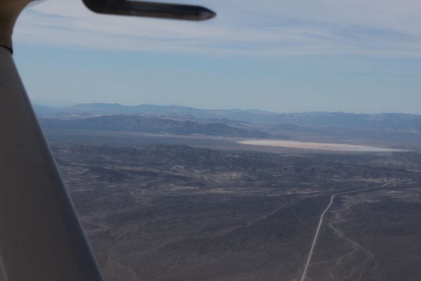
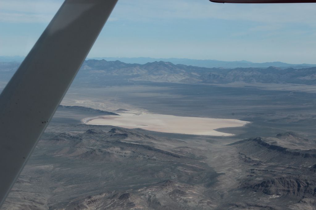
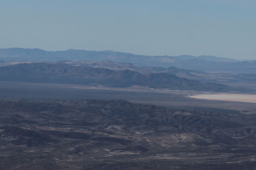
As I’m overhead the Pahranagat lakes, I can see a big dry lake on my right, “Texas Lake” (Delamar), sometimes used as a staging area for aircraft forward operations from unprepared runways.
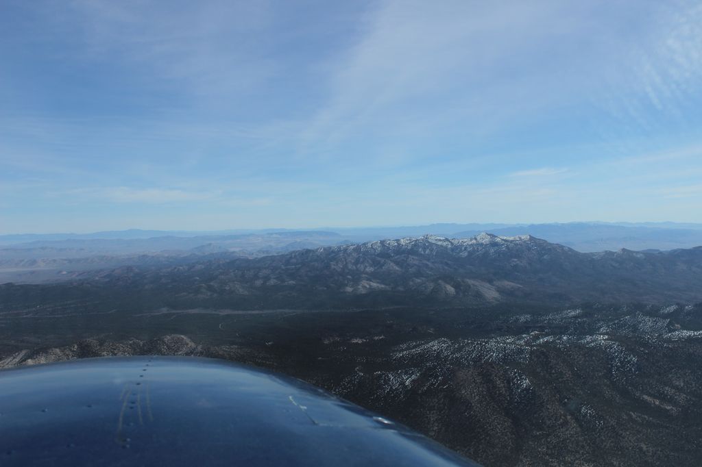
A few minutes later, approaching Alamo I get my first good glimpse at Groom Lake and its buildings. With the naked eye, it’s impossible to distinguish anything other than these big hangars, small metallic dots reflecting the sun. I’ve got my camera on the passenger seat and I take some pictures with my 55mm, an easy lens for photographing while handling the yoke, but not big enough for the distance.

I decide to turn left as soon as possible to get closer, while staying well out of the restricted area. I take a 270 heading, not directly towards the airbase as I don’t want to alarm the Blackjack air traffic controllers.
As I enter Tikaboo valley, with the straight ET highway (US 375) going north-west to Rachel and the Black Mailbox trail leading to the Area 51, I get a clearer view of the dry lake, the long runway and the various buildings.

I’m elated as this is something I wanted to see by myself, somewhere I wanted to come to for the last 15 years. And being there in this little Cessna, flying alone and wherever I may think of, it’s a dream come true.
It’s now time to turn a bit right to skirt the north-east corner of R4808. Bald mountain to my left hides the dry lakebed, then the main airbase. These are the last seconds for me to have a look at this most secret airbase. I don’t circle in the area because I don’t want to draw more attention. Having an F-16 escorting me away may be great for pictures, but this could be a sign that the sheriff is waiting for me on the ground, so that’s the last thing I want for now.
Approaching Rachel, I recognize Coyote Summit where I spent two long days this same week. And I’m now eager to discover from the air all the geographical report points the military pilots use during their Red Flag sorties. Over Rachel, I’ve got now a good view of No Name mountain, west of Bald Mountain. This lone butte is a good mark showing the northern frontier of Area 51, or the Container as the military pilots call it. They also have no right to penetrate that area and if they do, they’re sent back to their home airbase the next day with a bad grade for their career.

Farther west from No Name is Belted Peak, from where all the air-to-ground activity starts at Red Flag, and beyond it I can distinguish Quartzite Mountain, between the 74 ranges and the 75 ranges. I spent a lot of time studying the NTTR chart and reading about it ; that helps me identifying all these now.

I now turn east to my destination for the morning, Lincoln Co airport (Panaca town). This brings me just south of that long north-south Worthington range.

After a few minutes and an overhead of the Timpahute range mines, I overfly Irish mountain. This peak is used also by Blue Force pilots during Red Flag to report and prepare their collective and structures ingress towards the FEBA (or Forward Edge of the Battle Area).
I fly east over Hiko, hoping for a good tailwind on the return trip to Las Vegas. I’ve been having a headwind for the main 1.5 hours and the gas supply on the few Nevada airfields is scarce (Alamo and Lincoln has none for example). I now can see without any mistake a large gap in between two ridges : Pahroc Summit Pass, also known as Student Gap among Red Flag pilots. This is the main passage point for Blue Force pilots when it’s “push time”. It’s a lot better to be here in my Cessna during the weekend than during a Red Flag weekday.

After ten minutes, I see the small Lincoln Co airfield where I’ll have my lunch break, under the wing and in a 10 kts wind. The landing is uneventful and I find myself really alone on that parking. I’m amazed that nobody other than me, seems to enjoy the Nevada desert by plane, specially when you can be so close to where the most secret planes get tested.
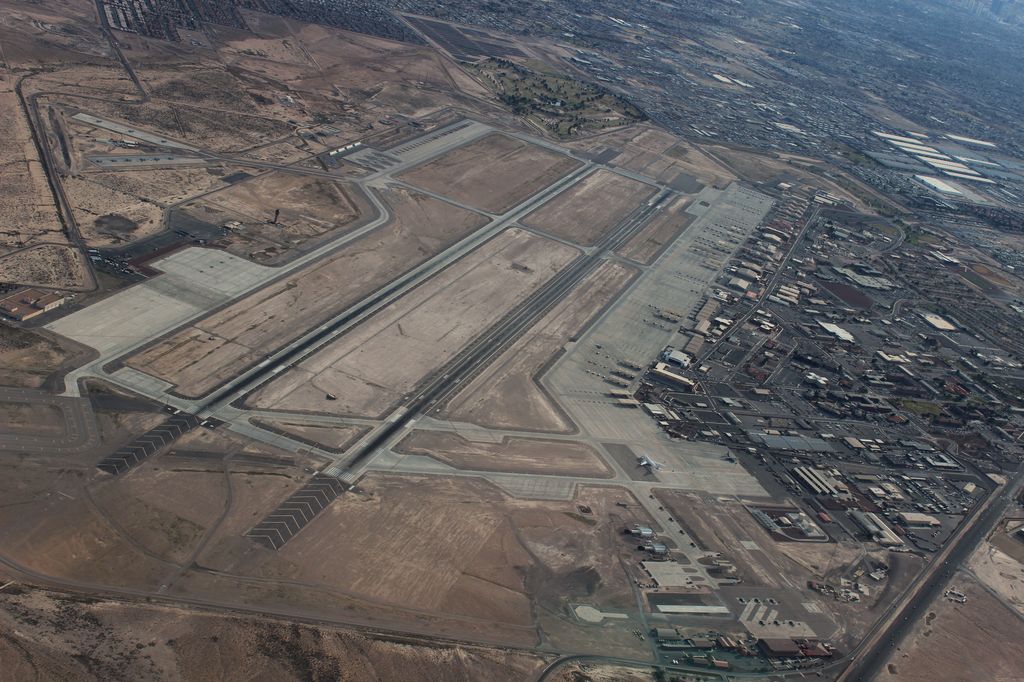
The return trip is straight as gas is a bit of a concern for me, having already burnt 1.7 hours, with a total endurance of 4 hrs. 80 miles out of Las Vegas, I get my clearance for the Bravo airspace and after passing the mines and plants of Apex, north of Sin City, I request to overfly Nellis AFB. Nellis Approach grants it and I can approach the base at 6,500 feet. After some pictures, I’m asked to take a westerly heading to North Las Vegas and I comply.
These few seconds allowed me to get a good souvenir of the big military airbase: the cherry on the cake.


