As North Korea conducted one of the largest-ever military drill a Global Hawk UAV (Unmanned Aerial Vehicle) could be tracked online.
On Mar. 26, at around 12.00AM GMT, a weird aircraft could be tracked online on the popular website Flightradar24.com.
The aircraft was not broadcasting its flight data using its ADS-B transponder, but could be tracked thanks to Multilateration (MLAT).
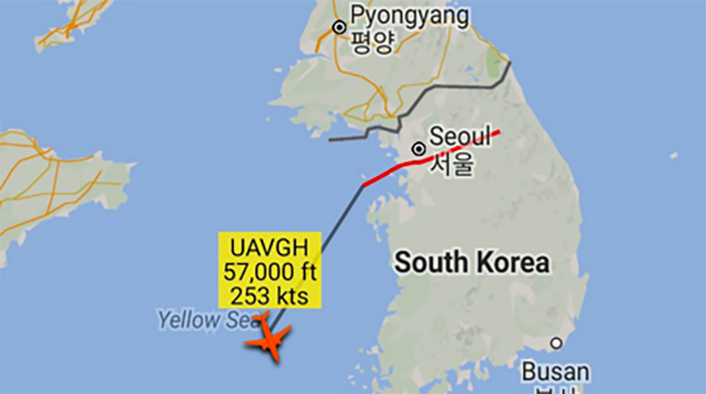
Interestingly, the aircraft was flying at 57K feet a bit too high for a conventional manned plane, but a standard operating altitude for a high-altitude ISR (Intelligence Surveillance Reconnaissance) platform as the Northrop Grumman Global Hawk.
Noteworthy, the callsign showed by the aircraft was UAVGH (UAV – Global Hawk?).
Umm… Something with a dodgy transponder code from South Korea.
UAVGH https://t.co/iO4wIYO7mP pic.twitter.com/6lBG9E99k4
— Civ & Mil Air ✈ (@CivMilAir) March 26, 2016
Although the ID of the aircraft can’t be verified, we can’t but notice that the mysterious aircraft appeared in the same hours North Korea conducted its largest ever drills, with hundreds of M-1978 Koksan 170 mm self-propelled guns & MLRS.
Just a coincidence?