MH370 contrails possibly spotted by Satellite over Indian Ocean before crash

On Mar. 24, Malaysian PM officially announced that Malaysia Airlines MH370 crashed in southern Indian Ocean, where a satellite might have spotted its contrails.

A large and difficult operation involving both patrol aircraft and ships has been in progress for days in southern Indian Ocean, more than 2,300 kilometers to the southwest of Perth, Australia.

Which “sensor”, antenna or intel provided the hint to determine that the aircraft headed towards the South Pole, instead of following the northern route, is unclear. Anyway, Malaysia’s PM has officially confirmed that the area currently being patrolled is where the aircraft crashed after more than 7 flight hours.

Did the investigator have a look at satellite imagery, looking for some contrails? Maybe. For sure imagery of the visible and infrared channel were used to look for a sign of the “zombie” MH370 flight, as done by a meteorologist, by Tim Vasquez, meteorologist.

Since Mar. 17, in an attempt to find contrails of the missing Boeing 777, Vasquez has published some interesting images of the Indian Ocean on his website Weather Graphics.
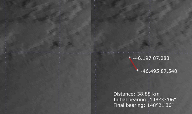
Such images, “enhanced to compensate for the dim early morning conditions” were also posted to the Professional Pilots Rumour Network community. PPRUNE users found a signature of what resembled a contrail (barely visible in the top image: left, the feature without annotations, right with measurements and coordinates).

“Analysis of the METEOSAT7 imagery showed that this signature does bear a close resemblance to a typical early morning cloud shadow from a contrail onto the top of a stratified lower middle cloud layer, which given the appearance of double layers and a slightly cold signature on the IR channels appears to be a low overcast altostratus or altocumulus later at about 5 to 10 thousand feet beneath an mid-level inversion. This is in a region with virtually no air traffic, and no published air routes within several hundred miles,” Vasquez explains.

However, considering the limited resolution of the imagery, the signature could also be something else, including noise in the satellite data or the back edge of a cirrus bands type of cloud.

Interestingly, the suspected contrail falls precisely within the search area where satellites and patrol aircraft are concentrating.

Provided this is really a contrail, it would be generated by an aircraft flying a heading of 210° magnetic (track 196°): assuming that the MH370 flew the last few hours with autopilot in heading hold mode of 210°, Vasquez backtracked the contrail in time, back to the western Strait of Malacca, where a turn southbound was started for unknown reason past 2.15 AM LT.

Here’s the track of the MH370 reverse engineered by Vasquez:

io-route-sum

Image credit: WeatherGraphics.com

Obviously, regardless to whether the one in the satellite is really an MH370’s contrail, the reason for a turn towards the South Indian Ocean remains a mystery. Especially if we consider that the aircraft, until 2:15AM LT, had followed a northern route.

By the way, at the time MH370 was last seen on radar (on radial 295 at 200 nautical miles from Butterworth airbase, Malaysia), the “zombie” Boeing 777 was more or less on the very same position as Emirates 343, a B777-300 from Kuala Lumpur, flying at FL340, 490 KIAS.

An interesting detail to fuel theories that MH370 was using another wide body to escape radar detection. Maybe, until something went wrong.

EK343

Image credit: screenshot from Flightradar24.com

H/T to Guido Olimpio for the heads-up


Enhanced by Zemanta
About David Cenciotti
David Cenciotti is a journalist based in Rome, Italy. He is the Founder and Editor of “The Aviationist”, one of the world’s most famous and read military aviation blogs. Since 1996, he has written for major worldwide magazines, including Air Forces Monthly, Combat Aircraft, and many others, covering aviation, defense, war, industry, intelligence, crime and cyberwar. He has reported from the U.S., Europe, Australia and Syria, and flown several combat planes with different air forces. He is a former 2nd Lt. of the Italian Air Force, a private pilot and a graduate in Computer Engineering. He has written five books and contributed to many more ones.

6 Comments

  1. option one:
    USS Pinckney warship which had a wargame in the disappearing location had shot down the plane and U.S had pressured the Malaysia to keep silence.
    option 2:
    rest of fiction stories.

    • So the USS Pinckney convinced the pilots to turn off the transponder, end all communication, and then turn 90 degrees left and fly for hours before shooting them down?

  2. What is confusing now is the last ACARS transmission was received at 1:07 in the morning of March 8. The system sent no data half an hour later, when it was due to do so.
    We were told later that the following is the timeline for the INMARSAT ping

    1:11 – INMARSAT ping would have been received, as apparently Boeing’s AHM report attempted to automatically transmit (thru Satellite?)
    – 1:19 – ‘Alright, Good Night’ at handover (supposedly by co-pilot)
    – 2:11 – INMARSAT ping would have been received, as apparently Boeing’s AHM report attempted to automatically transmit (thru Satellite)
    – 3:11 – INMARSAT ping received, as apparently Boeing’s AHM report attempted to automatically transmit (thru Satellite)
    – 4:11 – INMARSAT ping received, as apparently Boeing’s AHM report attempted to automatically transmit (thru Satellite)
    – 5:11 – INMARSAT ping received, as apparently Boeing’s AHM report attempted to automatically transmit (thru Satellite)
    – 6:11 – INMARSAT ping received, as apparently Boeing’s AHM report attempted to automatically transmit (thru Satellite)
    – 7:11 – INMARSAT ping received, as apparently Boeing’s AHM report attempted to automatically transmit (thru Satellite) near 40 Degree line
    – 8:11 – INMARSAT ping received, as apparently Boeing’s AHM report attempted to automatically transmit (thru Satellite) (thru Satellite) on 40 Degree line

    See the time and interval do not match the initial ping at 1:07. The plane took off from klia at 12.41am. The ACARS system should came to live at 12.37am 4 minutes before the plane took off and make the first handshake with the satellite. The system is programmed to send data at the interval of half an hour.
    The satellite suppose to receive the ping at the follow intervals:
    -12:37 (start up)
    – 1:07
    – 1:37
    – 2:07
    – 2:37
    – 3:07
    – 4:07
    – 4:37
    – 5:07
    – 5:37
    – 6:07
    – 6:37
    – 7:07
    – 7:37
    – 8:07
    Why there was a delay of 4 minutes for the Ping? Why there is timing differences for the pings? Why the interval change from half an hour to one hour? Auto self-programming? This is where you should question are they getting the correct satellite data.
    Is the satellite data truely belong to MH370? Is the following flight path derived from the satellite data reliable?
    The ACARS is using SATCOM (satellite communication) channel to transmit it’s data. MH370 might be using dynamic IP address instead of static IP address for the connection. How Immarsat determined which dynamic IP address belong to MH370 ? This is crucial for the accurate retrieval of the satellite data!
    There was a claim that the ACARS system was turned off between 1:07 and 1:19 after receiving the satellite received the first ping. How can the following ping occurred? 1:11 – INMARSAT ping would have been received, as apparently Boeing’s AHM report attempted to automatically transmit (thru Satellite?)

    It seem like from 1.11am until 3.11am, there was no ping from the plane. Only from 3.11am onwards the satellite received the ping. How can this happened? Does that mean the ACARS system was turned off between 1:11 and 3:11am?

    With a margin of error of 100 miles and not sure of the direction of the plane, INMARSAT can made a conclusion that mh370 end up in Southern Indian Ocean.

    From the above analysis, you can see two scenarios emerged:
    Scenario 1: Malaysia Airlines CEO Ahmad Jauhari told a press conference today that “we do not know when ACARS was switched off.” All that is known, he explained, was that the last ACARS transmission was received at 1:07 in the morning of March 8, and that the system sent no data half an hour later, when it was due to do so.

    Scenario 2: Prior to 3.11am, there was no ping received by the satellite. Ping at hourly interval instead of half an hour interval.

    Which scenario is the real one?

    Why I doubt the satellite data?
    It is because the authorities made an assumption assuming that the last radar contact with MH370 was near Pulau Perak when the military radar has no mean to identify the plane without collaboration with civilian aviation radars!

    http://www.washingtonpost.com/blogs/the-switch/files/2014/03/satellite-mh370.jpg

  3. It would be interesting to try this on NOAA polar orbiting images. I was very successful during the second Gulf War in determining the positions of orbiting B-1s and refueling tracks.

Comments are closed.