Doppler effect analysis on Satellite pings disclosed MH370’s final route

Even if the aircraft’s crash position could not be determined, Doppler effect analysis on SATCOM pings enabled INMARSAT to determine MH370’s final route over South Indian Ocean until a final, “partial ping,” received 8 minutes after the last known one.

Whereas search for debris from the missing Malaysia Airlines MH370’s Boeing 777 continues in a wide area located about 2,300 kilometers to the southwest of Perth, Australia, INMARSAT released new details to explain how the British satellite telecommunications company was able to exclude the so-called “north route” and focus on the southern one, pointing towards the South Pole.

As already explained on a previous post, hourly SATCOM system pings continued for more than 7 hours since the Loss Of Contact with MH370, until 08.11 AM LT.

Based on the round-trip times of such pings, two arcs made of all the possible positions located at the same distance from the INMARSAT satellite were drawn.

But it was further analysis, on Doppler Effect, as well as correlation between the “signature” of other B777s, that clearly indicated the aircraft southbound route.

Doppler Effect

The Doppler effect is something we are familiar without even knowing it. The sound of the ambulance’s siren or the train whistle are among the most common examples of how Doppler Effect works: the high pitch of the siren of an approaching ambulance suddenly drops as the vehicle passes you. Even if the source wavelength and speed do not change, movement of the source alters the wavelength and frequency of the sound.

You can use several online tools to calculate the frequency change induced by motion.

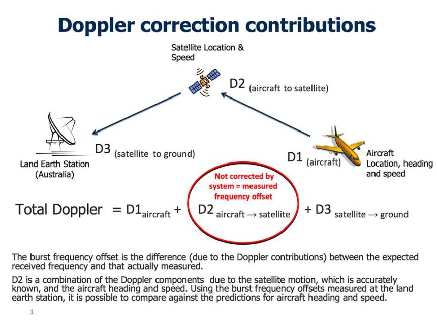
Since satellite pings are carried on a radio wave, the sensed wavelength, frequency increase or decrease depending on the fact the aircraft is moving towards or away from the satellite.

The difference between the expected received frequency and the actual measured one due to Doppler Effect is known as Burst Frequency Offset.

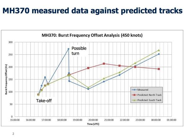
By comparing the Burst Frequency Offset due to Doppler on MH370 against the predicted one based on six B777s flying on the same day, INMARSAT could determine close correlation for the southern route and eliminate the northern one.

BFO MH370

Here’s an excerpt from UK Air Accidents Investigation Branch (AAIB) release that explains how INMARSAT calculated the route.

INFORMATION PROVIDED TO MH370 INVESTIGATION BY UK AIR ACCIDENTS INVESTIGATION BRANCH (AAIB)
25/03/14
[…]
As you have heard, an aircraft is able to communicate with ground stations via satellite.
If the ground station has not heard from an aircraft for an hour it will transmit a ‘log on / log off’ message, sometimes referred to as a ‘ping’, using the aircraft’s unique identifier. If the aircraft receives its unique identifier it returns a short message indicating that it is still logged on. This process has been described as a “handshake” and takes place automatically.
From the ground station log it was established that after ACARS stopped sending messages, 6 complete handshakes took place.
The position of the satellite is known, and the time that it takes the signal to be sent and received, via the satellite, to the ground station can be used to establish the range of the aircraft from the satellite. This information was used to generate arcs of possible positions from which the Northern and Southern corridors were established.

In recent days Inmarsat developed a second innovative technique which considers the velocity of the aircraft relative to the satellite. Depending on this relative movement, the frequency received and transmitted will differ from its normal value, in much the same way that the sound of a passing car changes as it approaches and passes by. This is called the Doppler effect. The Inmarsat technique analyses the difference between the frequency that the ground station expects to receive and that actually measured. This difference is the result of the Doppler effect and is known as the Burst Frequency Offset.
The Burst Frequency Offset changes depending on the location of the aircraft on an arc of possible positions, its direction of travel, and its speed. In order to establish confidence in its theory, Inmarsat checked its predictions using information obtained from six other B777 aircraft flying on the same day in various directions. There was good agreement.
While on the ground at Kuala Lumpur airport, and during the early stage of the flight, MH370 transmitted several messages. At this stage the location of the aircraft and the satellite were known, so it was possible to calculate system characteristics for the aircraft, satellite, and ground station.
During the flight the ground station logged the transmitted and received pulse frequencies at each handshake. Knowing the system characteristics and position of the satellite it was possible, considering aircraft performance, to determine where on each arc the calculated burst frequency offset fit best.
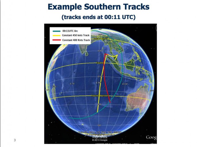
The analysis showed poor correlation with the Northern corridor, but good correlation with the Southern corridor, and depending on the ground speed of the aircraft it was then possible to estimate positions at 0011 UTC, at which the last complete handshake took place. I must emphasise that this is not the final position of the aircraft.


Here below is an INMARSAT image which shows the southern tracks for a ground speed of 400 and 450 knots ground speed.


MH370 tracks


Last “Partial” Ping

Noteworthy, INMARSAT collected  evidence of a partial handshake between the aircraft and ground station at 00:19 UTC, 8 minutes since the last acknowledged response. This partial ping is currently being investigated: there are several different theories, including the one that the final handshake was attempted outside of the hourly window, possibly at fuel starvation because of power fluctuations.

At 0115 UTC, when the ground earth station sent the next log on / log off message, no response was sent by the plane, indicating that the MH370 was no longer logged on to the network (because already crashed).

Lessons Learned

1) Pilots have the power to make aircraft almost invisible to radars. This will have to be addressed in some way, with some system capable to track the plane regardless of the aircrew’s willingness.

2) Black Box data have to be streamed via satellite and stored for the shortest time possible (until the next flight, then automatically erased) somewhere (for instance, in a Cloud Network architecture, to save money and have it immediately available, should the need arise).

Image credit: INMARSAT via AAIB

Enhanced by Zemanta
About David Cenciotti
David Cenciotti is a journalist based in Rome, Italy. He is the Founder and Editor of “The Aviationist”, one of the world’s most famous and read military aviation blogs. Since 1996, he has written for major worldwide magazines, including Air Forces Monthly, Combat Aircraft, and many others, covering aviation, defense, war, industry, intelligence, crime and cyberwar. He has reported from the U.S., Europe, Australia and Syria, and flown several combat planes with different air forces. He is a former 2nd Lt. of the Italian Air Force, a private pilot and a graduate in Computer Engineering. He has written five books and contributed to many more ones.

14 Comments

  1. David. Please. Back away from the keyboard. Stop with all of the speculation. You are killing whatever credibility that you had tried to build with respect to this site.
    Please don’t contribute to the nonsense and “noise”.
    Stick to what you have been providing to us for many years. Good, solid, aviation information.
    You are now throwing all your credibility into the toilet with a post like this, and others you have made, on this tragedy.
    If you want to go down the same road that CNN and other trash news organizations have, well, that is your choice.
    I thought more of you. Perhaps I have been mistaken.

    • Dear “Storm Viper”,

      you thought more than me? It seems that you didn’t even read the article…..

      The article does not contain ANY speculation: it’s based on INMARSAT data released by AAIB and includes a description of the Doppler Effect.

      If you want to criticise me you’r more than welcome. I’d appreciate you doing this with your real name, but it doesn’t matter. At least, read the article first and then you can complain. Otherwise your comment “kills whatever credibility” you may have among the great readers of this site.

      • Just to note, I for one found the articles about MH370 very interesting. It is an important and interesting event in aviation (though it is tragic above all, obviously).

  2. This is a massive wake up call and every manufacturer and operator needs to take steps to ensure this will not happen a third time. Positive track identification to the minute needs to be a default standard. If we need a satellite then launch them. If we need new equipment then buy that too. $200 Million for a plane that can vanish without a trace is unacceptable.
    If every airline got together and paid for a dedicated satellite connection and ground station to monitor it when an incident happens we would at least have enough information to mount a focused rescue effort instead of looking willy nilly and putting the rescuers at risk by searching areas that have little to no chance of having survivors.

    • There are satellite location terminals that are low cost and are used for tracking high value asserts. Orbacom and Iridium provide global systems (no gaps) that can track an asset. $100K tractor trailers, earth moving equipment, leased vehicles and nuclear cargo use them. I bet the insurance companies for the aviation industry are going to wake up over this.

  3. There is an inconsistency. The plotted frequency offsets are all positive, which indicates the aircraft was always receding from Inmarsat-3 F1. It is not possible to construct any path of MH370 from its last known radar position to the reported search area, without risking radar detection, unless the aircraft was APPROACHING the satellite for a period of time.

    http://www.washingtonpost.com/national/health-science/satellite-locates-malaysian-flight-370-still-flying-seven-hours-after-takeoff/2014/03/15/96627a24-ac86-11e3-a06a-e3230a43d6cb_graphic.html

    In fact, MH370 should have shown negative Doppler shift for more than an hour, probably 2 hours, after turning westward at about 01:21 Malay time.

    It’s possible the satellite technology doesn’t give the sign + or – of the frequency offset. But if we don’t really know if the plane was coming or going towards Inmarsat-3 F1, what conclusions, if any, can be drawn?

    • Chris, I concur both qualitatively and quantitatively. Moreover I’ve computed the doppler shifts from the lines plotted on the NYtimes and Washington post maps for a great circle route (i.e. the last four hours). the doppler shifts in the above plot are way too low, and the difference in the curves for the north and south routes is way too high.

      David Cenciotti, if you want I can show you my calculations.

      p.s. I’m not a crank. The orbital mechanics can’t produce the plotted data for the doppler shift for an L-band 1.5Ghz transmitter or for a statellite with a 1.67 degree inclination.

      • Chris, Charlie, keep us updated with whatever you find. I appreciate your comments because I strongly resist the idea of a plane flying towards no where unless it became a “ghost ship”.

      • I also computed the expected doppler for the first initial pings where the location, speed, track and altitude was known. For the 17:08 ping at 5.539619, 102.921048, 35000 ft, track 25 degrees @ 470knots, the doppler computes as -454 Hz. Whereas Inmarsat says their theoretical and measured value was 135. So are their figures really for absolute doppler, or do they have some offset / multiplication factor included in their figures. It would be interesting to see what your math says.

        Remember some satellites ‘invert’ the RF on the downlink such that negative doppler received by the satellite from the plane would be inverted and may become positive doppler on the downlink.

    • The arcs corresponding to each “ping” are concentric circles all centered on the stationary geocentric satellite. So there is complete north south symmetry, and any track to the south would have a mirror image track to the north that would fit the same data, including the doppler shift data.

    • Chris you point out the obvious flaw in Malaysia’s official BOF chart. The fact that it showed offset frequency increase until 17:22 UTC which implies velocity west, towards INMARSAT, when in fact MH370 was tracked by radar flying east away from the satellite.

      Any objective analysis has to conclude the Malaysian BOF chart is mutually irreconcilable with actual radar observations after take off and that the data is upside down.

      I made this opbservation on David Steel’s website and Airline Pilot Central websites back in March and was banned from the latter for my impertinence. A satellite engineer Mike Exner however came to the same conclusion and investigated.he realised that because the signal from MH370 was then re-transmitted back to Perth, the very act of retransmitting the data caused the signal to be inverted.

      Exner correctly recalculated the data adjusting for this data inversion and produced this BOF chart which I believe is the only true interpretation of MH370’s satellite signal offset, all praise to Mike Exner:

      http://i257.photobucket.com/albums/hh212/727Kiwi/EXNERBOFchart_zps8fbd08cd.jpg

      Exner’s correct interpretation however has been entirely ignored by investigators.
      Here is a simple example why the official BOF chart does not work. From 19:41 UTC the official BOF chart shows (offset frequency increasing) velocity towards the satellite, yet Malaysia insists MH370 took a path south from the Straits of Malacca which result in increasing displacement (distance) east away from the satellite. Again we are faced with mutually incomparable claims.

      http://i257.photobucket.com/albums/hh212/727Kiwi/MH370/indianoceantrackdisplacements_zpsac87ada5.jpg

      Then there is something else to consider. After claiming MH370 flew IGARI-VAMPI-GIVAL-IGREX, Malaysia then revealed this image to Chinese relatives at Beijing which contradicted its earlier claims:

      http://i257.photobucket.com/albums/hh212/727Kiwi/MH370/Lido_Hotel_Beijing_21March_zps2eb1b3f1.jpg

      Malaysia claims this to show radar tracking of MH370 flying a route crossing Pelau Perak (island) until it disappeared west. What Malaysia fails to advise is there were two other aircraft SIA68 and Emirates UAE343 also in the same airspace and these aircraft do not show up on the Butterworth radar image.

      http://i257.photobucket.com/albums/hh212/727Kiwi/MH370/UAE343Overlay_zps49d145d2.jpg

      One is forced to conclude that Malaysia perpetrated a hoax when they claimed MH370 flew west through the Straits.

  4. I remain skeptical that the Inmarsat data is a red herring. Originally the track was based upon one data point. Now we have 6 data points plus one partial since radar contact was lost. The partial data point occurring curiously off schedule with the previous hourly handshakes.

    This would be more conclusive if Inmarsat had data from overlapping satellite receivers (NSA/NRAO can you help?) to help triangulate these pings.

    Could the “Burst Frequency Offset” simply be a result of elevated temperature in the cabin skewing the oscillator of the transmitter? The large excursion from the 17XX to 18XX hour pings is perplexing. How does one account for such a great deviation?

    Could a flash fire throughout the cabin have caused the large frequency skew?

    How does one explain the aircraft flying past Australia radar yet NO reports of hits?

    Could the plane have been skillfully ditched at sea near final radar skin paint, following a fatal fire and drifted, with the Inmarsat terminal dutifully reporting (on its battery) for hours until the flotsam fuselage finally sunk?

    Could the frequency offset over next hours been result of the fuselage cooling down?

    Why no ELT transmissions?

    Curious no one mentions the Honeywell ELT in these aircraft already responsible for causing two fires (2013 AD/Recall issued) due to their own internal lithium battery problem.

    Hmmmmm????

  5. This discussion seems to be pre the latest data which has the plane flying faster and a search path more to the NE. The map above shows a slower path to the NE. What am I missing?

    Oherwise this is the best data I have seen, thanks.

Comments are closed.