What SATCOM, ACARS and Pings tell us about the missing Malaysia Airlines MH370

Eight days since the Malaysian Airlines flight MH370 disappeared somewhere over southeast Asia, the last known details about the missing Boeing 777 come from the onboard SATCOM system.

Very few details about the MH370 flight from Kuala Lumpur to Beijing, disappered from the skies on Mar. 7, 2014 have emerged. First of all we don’t know if it crashed or landed somewhere. Second, provided it was really hijacked as Malaysian authorities suggest, we don’t really know whether the pilot or co-pilot played an active role in the operation even if investigators are scrutinizing their profile and personal life.

Based on the information that were released so far, we have been able to draw several different scenarios, each featuring a certain degree of likeliness. The few details that were gathered past the loss of radio contact with the aircraft, come from satellites.

Let’s see why.

ACARS

ACARS is the acronym for Aircraft Communications Addressing and Reporting System. It’s an automated communication system used by commercial planes to transmit and receive messages from ground facilities (airline, maintenance department, aircraft or system manufacturer, etc). Therefore, along with the general information about the flight (callsign, speed, altitude, position, etc), these messages may contain what we can consider systems health checks.

ACARS is a service: airlines have to pay for it. According to the information available to date, it looks like Malaysia Airlines subscribed only to engine health monitoring that enabled MH370 to send data to Rolls Royce.

The ACARS system aboard MH370 was switched off some minutes before the transponder.

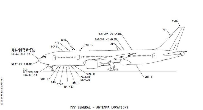
ACARS rely on VHF frequencies (indeed, you can track planes and decode messages with a simple radio receiver tuned on the proper ACARS frequencies and a software running on your computer) or SATCOM (SATellite COMmunication).

Although this is still debated, according to several pilots the ACARS transmissions can be switched off by the pilot from inside the cockpit, by disabling the use of VHF and SATCOM channels. This means that the system is not completely switched off, but it can’t transmit to the receiving stations.

SATCOM

SATCOM is a radio system that uses a constellation of satellites used to trasmit voice, data or both. As said, ACARS can make use of SATCOM to transmit its data to ground stations. Dealing with ACARS, the SATCOM system used by MH370 was linked to the INMARSAT network.

Inmarsat is a British satellite telecommunications company, which offers global, mobile services through a constellation of three geostationary satellites.

The system relies on “pings”.

Ping

A Ping is a quite common term for IT Networking. It refers to a utility used to test the reachability of a host on an IP network and measure the round-trip time (RTT) of the packets even if it is more frequently associated to the data messages themselves, or “pings”.

Similarly to what happens on a Local Area Network, satellites send pings (once a hour) to their receiving peers that respond to it thus signaling their network presence. Hence, these pings are no more than simple probes used to check the reachability of SATCOM systems aboard the planes.

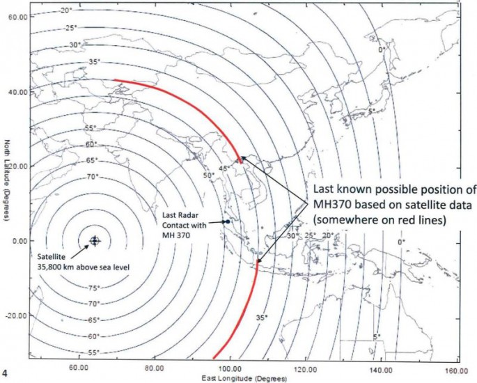
Based on details recently disclosed, the last response to a satellite ping, was sent by the SATCOM aboard MH370 at 08.11AM Malaysia time, some 7 hours past the loss of contact with the Boeing 777.

From the analysis of the time between request and responce it is possible to work out the distance of the plane which is a circumference of certain radius from the satellite based on which, two possible routes were drawn by the investigators.

The question is why the hijacker(s) did not prevent the plane from responding to pings: most probably, being a networking detail, not even pilots know that their system/antenna respond “I am here” even if the SATCOM is not being used by any onboard systems (i.e. ACARS).

INMARSAT positions


Top image: Boeing; above, Office of the PM of Malaysia

All the articles about MH370 can be read here (scroll down).


Enhanced by Zemanta
About David Cenciotti
David Cenciotti is a journalist based in Rome, Italy. He is the Founder and Editor of “The Aviationist”, one of the world’s most famous and read military aviation blogs. Since 1996, he has written for major worldwide magazines, including Air Forces Monthly, Combat Aircraft, and many others, covering aviation, defense, war, industry, intelligence, crime and cyberwar. He has reported from the U.S., Europe, Australia and Syria, and flown several combat planes with different air forces. He is a former 2nd Lt. of the Italian Air Force, a private pilot and a graduate in Computer Engineering. He has written five books and contributed to many more ones.

34 Comments

  1. Assume for a moment the south route was used: For what purpose would someone hijack a plane, fly it for 7 hours to end up crashing in a very wide ocean, without announcing reasoning for the hijack? Pretty useless, certainly for someone planning something like this. It’s not something you do by playing Flight Simulator.

    The north route sounds more serious when you are “in need of a plane” as a terrorist or otherwise “non-government supported” organisation. But in this case, wouldn’t there be a more usable or reliable way to get a plane from a more nearby location instead of flying it 7 hours from Malaysia? There are airports with commercial flights even a the more remote places where security is not at high levels. I highly doubt a country will “shoot before asking questions” these days. Sure, it happened before, and it’s a possibility, but shooting a 777 out of the air isn’t something you can cover up easily.

    When the reasoning was to kill a lot of people, turn around the plane and return to the nearest big city. No need to fly 7 hours. Certainly not if you can get loaded big planes more nearby.

    Another one I have read is that is was hijacked, but the pilot became lost. Flying over the ocean without knowing where to go. It’s not that pilots fly around with a map in their hand or watching the stars to navigate. Navigating has evolved a lot since Columbus sailed the Atlantic. Just type your favorite ICAO code into the computer and it tells you where to go, how far it is, if you have the fuel and if you’re lazy it will fly you there buy just pressing the LNAV button (yes, a bit simplified). And if someone is planning this whole thing, he/she will certainly know WMKK, WSSS or WIII to name a few ‘targets’.

    In short, what on earth happened to MH370?!

    • I totally agree with you, and I think this is exactely the mystery of flight MH 370. It does not show the signs of a technical failure/accident, but it neither shows the classic signs of a hijack.

      My best guess is that it was hijacked – of course with a certain plan in mind, and therefore all this mystery with concealing – but then something went wrong and it eventually crashed.

      • I lean towards this as well. Of course, it’s all so speculative… but with such little data I’m definitely not sold on an elaborate cover-up with the plane still intact for long if at all.

        I can hope for a movie plot miraculous ending with the passengers in part or in full being rescued dramatically, and human nature would predispose one to not want to give up hope, but logically/rationally, it’s hard to imagine a scenario in which there are survivors.

      • Exactly my point. And right now that’s where I stand as well. That it was a suicide mission but this is one time I hope I’m wrong and all passengers and crew are safe and sound somewhere, waiting to be freed.

    • “For what purpose would someone hijack a plane, fly it for 7 hours to end up crashing in a very wide ocean, without announcing reasoning for the hijack?”

      I’m sure there’s more than one answer, but here’s one I can think of – suicide mission with the intention of the plane never being found so it’s probably at the bottom somewhere in the indian ocean. Their team would then go (or already be at the crash site if they expected it to crash near there) and use their ship to clean up any debris it may have left behind.

      Another possibility is that the plane simply lost cabin pressure for any number of reasons and everyone went to sleep. Once it ran out of fuel it then crashed, unfortunately, at the bottom of the ocean somewhere.

      Another theory – the plane did go to 45000 ft for a short time right? And they said everyone would’ve passed out within I think it was 15 seconds, that is everyone except the pilots if they put on their own oxygen masks but disabled the use of it for the passengers/crew (if that’s even possible). So, the pilots then could’ve flown it wherever they wanted and is now, hopefully, hidden somewhere on an island or something. But why do that and not tell anyone anything. Why are there no demands? And nobody announced responsibility while proving they have the plane so this doesn’t make sense to me and so maybe it isn’t what happened.

      Another reason I can think of right now – The military shot it down by accident and have quickly covered it up by cleaning up the debris from whatever was floating on the ocean surface. All the while providing false statements to all media, like the responder being turned off, not providing the location of all the pings, etc. While not impossible, I do think it’s a little far fetched because this would be hard to do without any other country finding out from their own satellites or other equipment…unless of course it’s a big conspiracy, again, highly unlikely. Now, everyone who’s involved, are hoping the plane is never found and given enough time things just quiet down from there.

      So like most other people, I too wish to know what really happened to MH370, unfortunately, depending on what the truth really is, we may never know, especially if that was the intention right from the beginning.

      My best guess? It’s at the bottom of the ocean – a suicide mission by the pilot(s) or hijackers on board, with the goal being that the plane is never found. Maybe for insurance purposes. Maybe because of the stock market. Unfortunately, we may never know. So far it’s looking that way because really, NOBODY seems to know jack! All info provided is nothing but a squashed fly on the wall. And it’s not sharing the full truth, assuming SOMEONE alive knows what it is.

  2. Well what I really want to know now, how many times did this ping occur from this flight? And if more than this once, what are the location arcs that previous pings reveal?

    • One ping per hour for 7 hours = 7 pings, 7 circles. Why don’t they show the 7 arcs? You could probably see where it was headed, knowing the approximate speed.

      • Is it possible that the system only stores the last ping? Its only a handshake after-all.

      • Having only the last arc, if in fact this arc truely represents that the aircraft in question was somewhere along that arc, and for whatever reason not having the other (ping) arcs, we can be sure this is the hardest evidence we have concerning the position of the aircraft at that 8 oclock in the morning ping. If you trust the last ping and the geometric calculations derived from the satellite info, then the aircraft was in fact somewhere along that arc within a distance from the last transponder encoded position, limited by remaining fuel and winds. WE NEED THE OTHER PING ARCS….PERIOD. We could also safely deduce the aircraft was still in a condition to “handshake” with the satellite during that morning of the last ping…in other words “in once piece”. We could also safely say the aircraft was out or nearly out of fuel by 8:00 AM as well, given the assumption it was airborne the entire time. I say the aircraft was on the ground safe and in one piece somewhere along that arc by 8:00 AM….what you say ?

        • YES, WE NEED THE HOURLY PINGS. They may tell us nothing, or they may prove to be a key to the mystery.
          For Example: If any two pings are separated by 500 miles, we can assume that the aircraft flew straight toward (or away from) the satellite. If the arcs overlap, the plane was either circling or flew parallel to the satellite during that 60 minutes.

          I have tried to get CNN and the NYTimes to move on getting more hourly ping information, but so far I have not seen that in a story or on the air. Anyone who’s a whiz at trigonometry could sketch out a range of possibilities along the 811 arc IF WE HAD MORE DATA from the earlier pings.

          Perhaps the 811am arc already takes the previous information into account, but no one has confirmed that information.

          Attached is a theoretical plot…knowing the direction east or west the plane was travelling might show that it’s direction was as erratic as the altitude early in the flight.

          • As I understand it, the geosyncronous position of the satellite as compared to the aircraft’s position make it possible to calculate an angle between the target and satellite in degrees based on the distance from the target. This distance is determined by a time measurement…time it takes for a signal that travels at a known speed to get from point A to point B (considering the curvature of the earth and things I’m not even smart enough to consider !) All we know at this point is an “angle” relative to the satellite based on how long the line is (distance) drawn from the satellite to the target. We draw a circle on the surface at that angle and can deduce that the target is somewhere on that circle. If we wait an hour and take another reading, assuming the target is moving, the angle between the target and the satellite could change (unless it is traveling along the first arc). Draw another circle based on the new angle calculation and you have two circles, one larger or smaller than the other (they wont intersect). The aircraft is somewhere on the new arc, however without knowing where the target is on the arc, we still cannot determine direction of flight with any useable accuracy. Am I thinking correctly ?

            • Almost right, the problem is that time isn’t known. GPS works because time is known at the satellites and at the receiver both. But with times not known to nanoseconds there is not way to draw the arc you suggest.

              • In any case, an arc has obviously been reported and not as I suggest. Are you saying this arc could not have been determined using the ACARS handshake communication between the satellite and the target ? I honestly do not know, however, if it is impossible, then this is just more mis-information. Wouldn’t that be interesting.

              • Below is something I learned through some research.
                “The management unit/communications management unit (ACARS box onboard the aircraft) is the router. Its function is to route a downlink by means of the most efficient air-ground subnetwork.” The ACARS unit is pre-programmed with a table oulining a heirarchy which tells the unit whether or not to use land based VHF, HF, or Satellite as a means to relay information. I assume that if the aircraft is within reach of a land based VHF reciever, then the data will be transmitted via that link, rather than transmitting to a satellite. Having said this, if during the hours previous to the last “ping” the aircraft was in a position which put it in range of a “land based VHF reciever”, then it would have responded to the “ping” directly to that “land based” station. Could this be a clue as to where the aircraft was during the time period between 1:30 AM and 8:00 AM, and does it tell us why there is missing “ping arc data” previous to the 8:00 AM ping ?

                • IMHO there is still a matter of time. If a “handshake” involves a
                  databurst from satellite and a reply from aircraft then time can be
                  measured – assuming the turn-around time in the aircraft is known. In
                  other words, it is downlink time plus processing time at the aircraft
                  plus uplink time. But if the latent time is variable, for example if it
                  is trying a VHF reply before initiating the satellite reply then latent
                  time might be indeterminate and thus range is also.

                  But again we’re working with way too little information which equals 0% reliability!

            • You can determine a relative speed towards to satellite. E.G. If the radius of the circle decreases by 100miles the relative speed towards the satellite is 100mph. Since one can reasonably assume no plane is traveling at 100mph we know the rest of that speed was spent traveling along the arc of the original circle (or turning around). This is most likely why there is a gap between the north, and south arc. However this gap hasn’t been explained by the malaysia government so they may have ruled it out for different reasons.

              • My understanding is the area where the gap is has been ruled out because they’re reasonably sure it’s been well searched by boat/plane/whatever, and it’s also within the range of what the Malaysian military radar could pick up if there were something to pick up (I think that’s it, don’t quote me). They’ve bungled the handling of this in the media, but it’s a plausible explanation to rule that section out. Besides, if it really were flying around for SO long, wouldn’t it basically have to go in a circle or along a very random route to still be so close to the area? I have no idea what happened but if one is going to divert a plane like this, why would you just hang around? My layman’s instinct is that if anything, it’s more towards the middle to far edges of those arcs…

        • I hate to get into the weeds of speculation, but the reason I googled the topic of the pings and landed on this post was because Rachel Maddow basically very calmly and undramatically brought up this point about the intermediate pings–a very journalisticly “this is a question I have, we don’t have an answer as of now, it seems important.” We do need them… but if investigators have them, should we be surprised they’re not public knowledge? If indeed the plane managed to land, would they want to give up all they know to the media? Highly doubtful. Didn’t the US also halt the activity of the ships that had been searching the ocean? Unless it really is because of a tense relationship among investigators of the different countries, I doubt they’d stop that without a darn good reason. Presumably, other countries are still searching by ship… but perhaps the US is targeting resources elsewhere.

          I hate that I sound like a conspiracy nut… but the more we learn, the more it would seem this is a bad, bad situation. If they do in fact have a pretty specific idea of these pings that they are currently working off of, as curious as I am, I’m not sure I’d want that information public before everything is a little clearer.

          • Well said, and I subscribe to your feelings wholeheartedly. We all of course are standing in the “weeds”. I’m sure alot of us are also looking out through them…if not out of pure curiousity, then it is because the solution will only be had from analysis of the facts….somewhere outside the weeds.

            • What if it landed and refueled on southern tip of Maldives where residents claim they saw a low-flying jumbo jet? Could it have made it to the otherhalf of the ping circle
              ?

          • You are correct. But be assured the airline knows how much fuel was on board when it departed. Fuel loads are calculated using aircraft gross weight, passenger/cargo loads, planned trip distance including winds, and alternate airports. It can reasonably be said that it had at least enough fuel to make it to Beijing….wouldn’t you agree ?

    • It’s interesting that they either A) don’t want to show all the pings and the TDOA arcs from Inmarsat or B) can’t show the pings.

    • The article says pings are once an hour. But I agree with John about wanting to know the location arcs of the previous pings. For example, are they all different, showing the plane was traveling. Or are the some of the last ones the same, showing it might have stopped. Or …?

  3. It’s a hijack. Either the airframe is going to be used in the future or it was meant to grab a passenger or something inside the cargo hold. A suicide doesn’t make sense. Why go through the action of disabling the ACARS and transponder if someone on the flight control want to kill themselves.

    • “Why…?” Because it has to look like an accident if your loved ones are going to collect insurance…….

      • What sort of a lunatic would go to these lengths for a personal life insurance claim?

        Chances of success: minimal,

        Chances of jail time: very high,

        Better options: beyond measure…

  4. in almost all these disasters it is chain of events and not a single cause…my (unproven) theory starts with a cable/electronics fire on the flight deck which would explain the lack of communication and transponder signals and it could possibly have prevented getting power from the backup systems to the flight deck) …and ended in the crew misreading the mechanical backup compass and flying out to sea, running out of fuel and ditching (no debris field)….

    eventually we will find out what really happened…

    • The Pilot spoke to ATC after the transponder was switched off. I am puzzled as why ATC did not alert to this ?

Comments are closed.