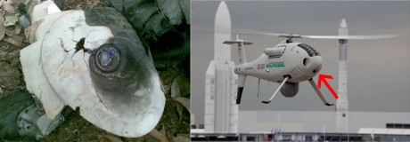
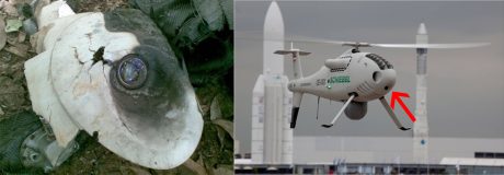
On May 27 a drone flying a routine surveillance mission along the coast of Somalia crashed in a remote area near the shoreline of Mogadishu.
The Pentagon confirmed the loss in Somalia after the Al-Shabaab group published some photos of the wreckage on Twitter but did not confirm the remotely piloted aircraft was shot down.
The UAV was found near Bulo Marer (a town in the southwestern Lower Shebelle region) the same place of a French Intelligence failed operation to rescue Denis Allex in January 2013.
Based on the images of the parts collected by Al-Shabaab, the mysterious drone can be identified as a Schiebel Camcopter S-100 small UAV (unmanned aerial vehicle).
The Aviationist’s contributor Giuliano Ranieri highlighted the pieces of the Camcopter that have survived the crash and that can be clearly identified among the debris.
The little S-100 drone is produced by the Austrian company Schiebel.
It weights only 200 kilograms (440 lb) but with an endurance of 6 hours, a maximum speed of 220 kilometres per hour (140 mph), a ceiling of 5,500 metres (18,000 ft) and various payloads (including electro-optics and infrared sensors) it can carry out a wide array of clandestine missions.
If the UAV itself has not so many secrets, what is extremely interesting is the use of this type of drone by the U.S.
Even if it is impossible to say what the aircraft was doing, it is quite likely it was flying an espionnage mission for the CIA.
In 2009, Boeing and Schiebel made a demo for U.S. Army Special Operations Command (USASOC) at Ft. Bragg, North Carolina about the integration of the S-100 and ground unmanned systems for PSYOPs missions in-theatre.
“Equipped with an American Technology Corporation loudspeaker capable of addressing crowds at a distance of up to 2 km, a leaflet drop capability, as well as an IAI POP300 EO/IR camera payload. The John Deere R-Gator unmanned Ground Vehicle (UGV) was also equipped with a loudspeaker augmented with the Trident, Inc. data link, demonstrating the potential for teaming UGVs with an UAS. […] The S-100 was utilized to survey the area and provide real-time aerial intelligence, as well as to address the public and drop information leaflets.”
Related articles


