New open source tools complement ADS-B and allow you to spot military activities (including close encounters) all around the world.
We have been researching ADS-B as a tool to carry out OSINT (Open Sources INTelligence) on aircraft movements for more than 10 years now. Some of our most loyal readers will probably remember when, during the opening hours of Operation Odyssey Dawn, we wrote about the tankers that could be tracked online as they supported the first air strikes in Libya.
Since then, Flightradar24, PlaneFinder, Plane Plotter, and (more recently) ADSBExchange have grown their popularity becoming very well known apps and websites that let anyone (aviation enthusiasts, geeks, journalists, etc) track flights in real-time just using an Internet connection and their desktop, laptop or smartphone.
Both these “services” (some of those are completely free, others requiring purchases to unlock some of the features), rely on Mode-S transponders with ADS-B capability. Here’s what we wrote about this technology in a previous article here at The Aviationist:
The ADS-B system uses a special Mode-S transponder that autonomously broadcasts data from the aircraft’s on-board navigation systems about its GPS-calculated position, altitude and flight path. This information is transmitted on 1090 MHz frequency: ground stations, other nearby aircraft as well as commercial off-the-shelf receivers available on the market as well as home-built ones, tuned on the same frequency, can receive and process this data.
The flight tracking websites rely on a network of several hundred (if not thousand) feeders who receive and share Automatic Dependent Surveillance-Broadcast (ADS-B) transponders data and contribute growing the network and covering most of the planet.
Obviously, only ADS-B equipped aircraft flying within the coverage area of the network are visible.
While not all aircraft broadcast their GPS data, in those areas where coverage is provided by several different ground stations, the position can be calculated also for those planes that do not broadcast their ADS-B data by means of Multilateration (MLAT) of their Mode-S transponder signals. MLAT uses Time Difference of Arrival (TDOA): by measuring the difference in time to receive the signal from four different receivers, the aircraft can be geolocated and tracked even if it does not transmit ADS-B/positioning data.
Although the majority of the aircraft you can track are still civil airliners and business jets, today, military aircraft belonging to different air forces as well as contractor and special operations planes can be regularly tracked while flying over Iraq, Afghanistan, Tunisia, Egypt, as well as over the Med, Black Sea, Baltic, South China Sea and and many other “hot spots”.
In the last few years, other interesting tools have emerged to complement the ADS-B monitoring. Satellite imagery is among them. By combining ADS-B data with satellite shots you can get an even better “picture” of what is happening in a certain part of the world. This is what our close friend @Gerjon_ has been increasingly exploring in the last few years. A Dutch image analyst and aviation tracker, he’s started working on publicly available satellite shots to gather additional details on the military activity all around the world exposed by Mode-S/ADS-B data.
“Since around 5 years there are 2 Sentinel-2 satellites orbiting around Earth,” @Gerjon_ explained in an email to us.
“With their pixel size of 10 meters (at ground level), you are able to see and *just* able to identify aircraft. For example, an Ilyushin Il-76 will be around 5 pixels wide and long. The great bit is that these images are easily accessible (without login) for anyone, here.”
The main challenge of this kind of investigation is usually to know where to look.
“For aircraft using ADS-B in areas with ADS-B coverage, the solution is pretty simple: all you need to do is find the flight track on a tracking website, find the exact time a satellite image was made over that area, and look for the aircraft in the satellite image around the location indicated on the tracking website. For most civil aircraft and some military aircraft (P-3, P-8, RC-135) this is pretty easy because their light grey or white color is a clear contrast with the environment, especially over sea.
Some darker grey military aircraft (B-52H) can also be spotted on Sentinel-2 imagery, but the lack of contrast makes them much harder to see. For smaller aircraft (e.g. fighter jets, RQ-4 Global Hawk) size is an extra challenge: they show up less brightly because the aircraft only fills part of the pixels. Aircraft show up as three different aircraft (a red one, a green one and a red one for a white aircraft) because the satellite image is created band by band, so the different colors are made a fraction of a second after each other. Finding one aircraft usually takes me anywhere between a minute and an hour. Because there’s a revisit time of 5 days (so it will take 5 days for an identical satellite image to be taken, although an area can be covered by multiple images), there is often no image available.”
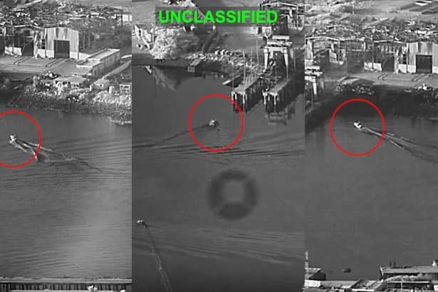
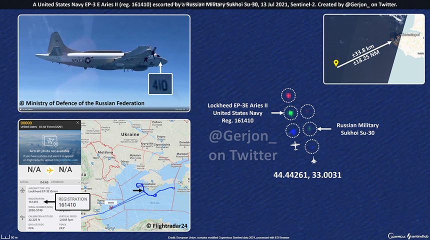
By using this technique, @Gerjon_ was able also to spot the recent close encounter between a U.S. EP-3E Aries II and a Russian Su-30SM over the Black Sea.
“After @Ameliairheart informed me about the event over the Black Sea, I browsed to the Sentinel EO-Browser and matched up the flight data and Sentinel-2 images. I managed to identify the EP-3E Aries II over the Black Sea without trouble by matching it up with Flightradar24 – it was pretty easy given the high quality of the track on Flightradar24 and the clear weather conditions. The Sukhoi Su-30 simply happened to be close to the easily findable P-3 at the moment the satellite image was made. Without the Flightradar24 track, finding the Sukhoi Su-30 (going by the Russian Ministry of Defence’s tweet) would have been considerably more difficult, because I would have no idea where to look, since they use no ADS-B.”
👀A U.S. Navy Lockheed EP-3E “Aries II” (🇺🇸161410) was intercepted/escorted by a 🇷🇺Sukhoi Su-30 today.
🛰️Sentinel-2 imagery shows a 2nd aircraft ±130m from the EP-3E.
The EP-3E was ±18.25 NM from 🇺🇦🇷🇺Crimea.
📍44.44261,33.0031
H/t @ameliairheart for pointing me at the event👍🏻 https://t.co/zdfeWbdjVj pic.twitter.com/sKNINLerhA
— Gerjon | חריון (@Gerjon_) July 13, 2021
To finish off: here are some of his earlier finds on Sentinel-2 which you may find interesting too.
2x RQ-4 Global Hawks around Crimea (very hard to find given their size and cloud cover):
Two 🇺🇸United States Air Force RQ-4B Global Hawk UAVs spotted on 🛰️Sentinel-2 imagery around 🇺🇦🇷🇺#Crimea yesterday:#FORTE10: 📍44.35357, 33.08175, 53,000 ft#GINGR68: 📍43.63087, 34.49926, 55,000 ft
(Note how RQ-4B has 40 m wingspan – and GINGR68 is 4 10-meter pixels tall!) pic.twitter.com/Ti13Q4uedj
— Gerjon | חריון (@Gerjon_) May 2, 2021
Various aircraft including aerial refueler with receivers, over the North Sea:
🛰️Sentinel-2 imagery of the North Sea yesterday shows:
1. P-8A Poseidon (🇬🇧ZP804/#STNGRY01);
2. E-3A Sentry (🇱🇺LX-N90459/#NATO06) being refueled by a KC-10A Extender (🇺🇸82-0191/#NACHO81);
3. 2 Eurofighters Typhoon (est.) alongside the Airbus KC-2 VIP Voyager (🇬🇧ZZ336/#TARTN58). pic.twitter.com/tsmlExyPBp
— Gerjon | חריון (@Gerjon_) June 19, 2021
A recent, unidentified American ferry flight from the Gulf, a bit harder to see:
Two (so far) unidentified, likely U.S. Military aircraft being ferried west across the Mediterranean Sea today, first by #BLUE45/🇺🇸60-0347, later by #BLUE46/🇺🇸63-7992, seen here.
BLUE45 was first tracked over 🇶🇦#Qatar around 04:00 UTC.
📍39.48043, 7.96062 pic.twitter.com/pFUznbvOkh
— Gerjon | חריון (@Gerjon_) July 12, 2021
A Boeing B-52H Stratofortress likely returning from operations over Afghanistan, very hard to see in the EO Browser:
Earlier, I found 🇺🇸60-0033, a United States Air Force B-52H Stratofortress strategic bomber nicknamed “Peace Persuader”, spotted on 🛰️Sentinel-2 over the Gulf of Oman, returning from a sortie over 🇦🇫#Afghanistan (est.), on 24 May around 07:00 UTC.#GRIMM21 pic.twitter.com/FprKf0AnfH
— Gerjon | חריון (@Gerjon_) June 11, 2021
6x United States Air Force Boeing F-15 Eagle heading east over Germany, contrailing:
Remember how @ennolenze spotted a REAPER flight of 6x 🇺🇸F-15 Eagle over 🇩🇪#Germany, about a week ago?
They were also spotted on 🛰️Sentinel-2 satellite imagery! It can nicely be seen that it’s a flight of 6, with #2 and #5 slightly further back. https://t.co/UFZ3MLQeKR pic.twitter.com/rCk6hPHi0P
— Gerjon | חריון (@Gerjon_) April 27, 2021