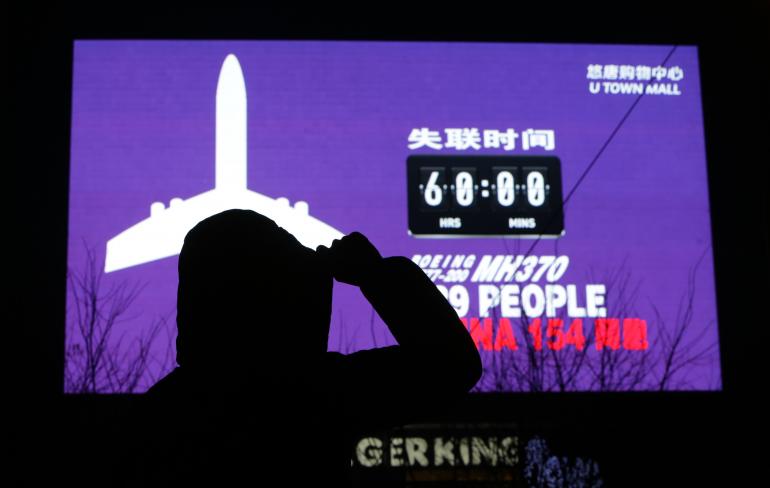
Let’s try to summarize all what is known to date about the mysterious MH370 flight.
This post contains a complete review of all the Malaysia Airlines 370 story, with new and revised details, update data and findings.
Facts
1) MH370 took off normally and headed on course to Beijing as planned. Just before Loss of Contact (LOS) the aircraft turned right to HDG040°. At the time the transponder stopped transmitting, based on ADS-B data, the aircraft was flying at FL350.
2) MH370 was following the usual route to Beijing.
3) Based on reports, the weather in the area was good.
4) The last ACARS transmission was 01:07AM local.
5) Reports surfaced yesterday that the aircraft either: turned westwards before the last voice transmission – or- entered two new waypoints in the FMS (see ADS-C section).
6) The last radio comms were “All right, good night” transmitted to Malaysia Air Traffic Control at hand-off to Vietnam control. Vietnam was not contacted. It has been reported it was the First Officer’s voice. Although it is not a standard phraseology reply, the “good night”, “ciao”, “au revoir” etc way to greet ATC at hand-off is quite common and, per se, it does not constitute any evidence of something wrong in the cockpit.
7) The transponder stopped transmitting at 1:21AM LT.
8) There are reports of a climb to 45,000 ft, uneven descent and some changes in altitude. However, this changes are based on primary radar, and altitude data is uncertain at that distance from radar.
9) According to the Malaysian authorities, there were subsequent primary radar returns to the west of the Malaysian peninsula, over the Strait of Malacca and then north west. This is assumed to be a real return from MH370 even if based on primary radar echo.
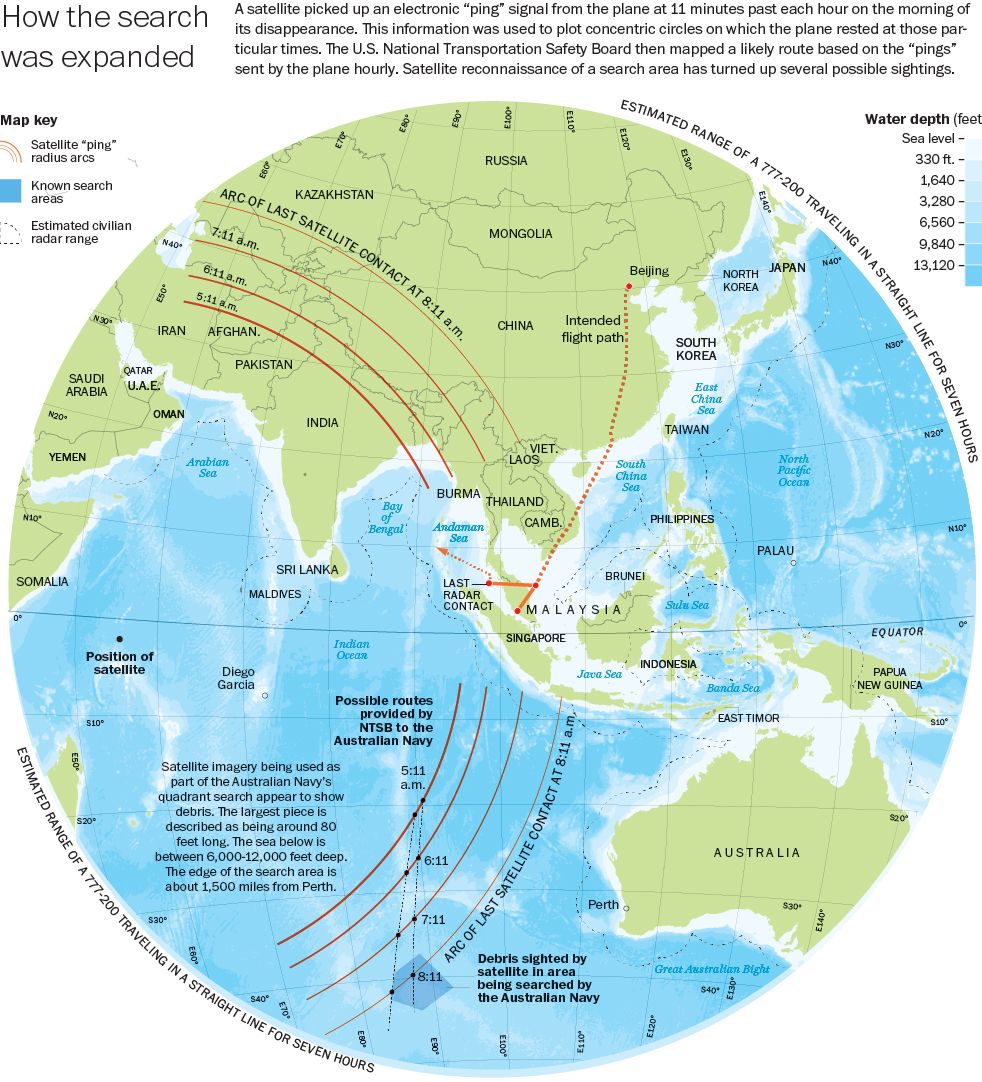
10) SATCOM (see below for details) satellite system pings continued for 7+ (last ping at 08:11 local) hrs after LOS (loss of signal)
11) SATCOM pings do not locate the aircraft but based on correlation to signal strength latency, satellite height, it is possible to draw arcs (of a circumference centered on the satellite with radius = distance from the satellite) where the last ping may have been located. The arcs identify a series of points at the same distance from the satellite and are located along two directions, the first is north from Andaman Sea to Turkmenistan; whereas the second is south, over the Indian Ocean from southwest Malaysia to southwest of Australia. The last primary radar reply came from a point that is coherent with the northern arc.
12) The last SATCOM ping replied by the aircraft reportedly was at 8:11 am Malaysian time. At that time it would be dark on the north arc and light over the south arc.
13) SATCOM pings are hourly – so the 8:11 ping could be up to 1 hour before the aircraft stopped ‘pinging’: the aircraft onboard systems could reply to ping (for more details read below) even if the aircraft had landed, while it is difficult to believe they could reply after crashing.
14) A pilot of another plane in the air when the aircraft failed to contact Vietnamese control, heard a weird “mumble” or noise seemingly coming from a stuck microphone from MH370 but there is no way to confirm this.
15) According to the Malaysian PM, the way the aircraft has flown since LOS make investigators believe it was a deliberate action.
16) Reports of sightings in Maldives, landing in China etc have been debunked. Thailand has admitted to have possibly tracked the plane on Mar. 7, after LOS, but only gave this information some 10 days after the disappearance.
17) All the previous alleged sightings of the aircraft debris (Chinese satellite images, Greek ship reports, Tomnod crowdsourcing initiative etc) did not find anything that could be related to the missing plane.
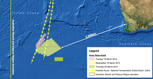
18) Based on satellite imagery collected on Mar. 16, search and rescue aircraft, including a P-8A are investigating possible debris located 2,300 km to the southwest of Perth, Australia.
Timeline
1.07 am – Last ACARS transmission.
1.19 am – Last verbal communication “All right, good night” from the plane; believed to be the co-pilot
1.21 am – Transponder stopped transmitting (turned off or failed)
1.30 am – Civilian (primary) radar lost contact
1.37 am – Expected ACARS transmission; not received
2.15 am – Last military primary radar contact
8.11 am – Last (hourly) satellite handshake
ACARS
ACARS is the acronym for Aircraft Communications Addressing and Reporting System. It’s an automated communication system used by commercial planes to transmit and receive messages from ground facilities (airline, maintenance department, aircraft or system manufacturer, etc). Therefore, along with the general information about the flight (callsign, speed, altitude, position, etc), these messages may contain what we can consider systems health checks.
ACARS is a service: airlines have to pay for it. According to the information available to date, it looks like Malaysia Airlines subscribed only to engine health monitoring that enabled MH370 to send data to Rolls Royce.
The ACARS system aboard MH370 last trasmission was at 01:07 LT.
However, it has emerged on Mar. 18, that last trasmission included new way-points that were possibly entered before the loss of contact, using the FMS. This would require ADS-C (see below).
ACARS rely on VHF frequencies (indeed, you can track planes and decode messages with a simple radio receiver tuned on the proper ACARS frequencies and a software running on your computer) or SATCOM (SATellite COMmunication).
Although this is still debated, according to several pilots the ACARS transmissions can be switched off by the pilot from inside the cockpit, by disabling the use of VHF and SATCOM channels. This means that the system is not completely switched off, but it can’t transmit to the receiving stations.
SATCOM
SATCOM is a radio system that uses a constellation of satellites used to trasmit voice, data or both. As said, ACARS can make use of SATCOM to transmit its data to ground stations. Dealing with ACARS, the SATCOM system used by MH370 was linked to the INMARSAT network.
Inmarsat is a British satellite telecommunications company, which offers global, mobile services through a constellation of three geostationary satellites.
The system relies on “pings”.
Ping
A Ping is a quite common term for IT Networking. It refers to a utility used to test the reachability of a host on an IP network and measure the round-trip time (RTT) of the packets even if it is more frequently associated to the data messages themselves, or “pings”.
Similarly to what happens on a Local Area Network, satellites send pings (once a hour) to their receiving peers that respond to it thus signaling their network presence. Hence, these pings are no more than simple probes used to check the reachability of SATCOM systems aboard the planes.
Based on details recently disclosed, the last response to a satellite ping, was sent by the SATCOM aboard MH370 at 08.11AM Malaysia time, some 7 hours past the loss of contact with the Boeing 777.
From the analysis of the time between request and response it is possible to work out the distance of the plane which is a circumference of certain radius from the satellite based on which, two possible arcs containing all the final points were drawn by the investigators.
ADS-C
ADS-C stands for Aircraft Dependent Surveillance – Contract. It is a dependent system (depending on the aircraft using it) that sends information based on a “contract” agreed by the controllers and crew. Information can include altitudes, estimates, coordinate for next waypoints and subsequent waypoint.
ADS-C can be programed to report periodically, on demand, on event. It can be initiated by the crew in an emergency.
Based on the revelations that the waypoint past the point of LOS were known to the authorities, it can be assumed that either, ACARS report at 1:07 included the “Predicted Route Group” or that they just meant that the path followed by MH370 was seemingly flown automatically, as if the plane’s primary radar tracks match with waypoints on a published airway.
ADS-C is transmitted via ACARS (which, as said, can use SATCOM, VHF or HF channels).
ELT
ELT – Emergency Locator Transmitter. It is a battery powered system that transmits on the guard frequency (121.5 MHz on VHF and on 406MHz to satellites. If can’t transmit from under water.
Mobile Phones
Although this topic is quite debated, reports say that no cell phone belonging to people on board registered with network towers. This may depend on the altitude the aircraft, the route (above the sea), or the fact that they were either seized to passengers or these were unconscious hence unable to switch them on.
Pressurization / Hypoxia
Cabin pressurization can be regulated by the pilots. This means that cabin could be depressurized to the airplane’s current altitude using manual pressurization.
In the event of the reported climb to 45,000 feet (determined based on primary radar – hence, to be confirmed), masks would deploy providing passengers Oxygen for 12 to 20 minutes (usually, just the time required to descend to below 10,000 feet). After that, passengers would lose consciousness and, at some point, they would die. Pilots O2 lasts more.
The same effect would be achieved at much lower altitudes: the main difference would be that death would arrive earlier at higher altitude (45K above the aircraft max altitude).
Theories
There are so many active theories that is almost impossible to list them all. We’ll try to list the most significant ones. Please consider that a “composite theory” made by hijacking and subsequent failure is possible as well. We will not consider such mixed theories.
Anyway, the main question here is: did the aircraft suffer an in-flight emergency or not? Although this author still believes that the aircraft was diverted from its initial planned route by a pre-planned action, the possibility it experienced a catastrophic emergency can’t be completely ruled out. Still, it seems to me a bit far fetched that the B777 suffered a failure that disabled the transponder, radio, ACARS, etc. but (possibly) left the plane capable to fly (on autopilot?) for 7 hours.
Hijacking
The aircraft is hijacked. Then it crashes after 7 hours for fuel starvation.
Based on the current information, this is a likely scenario (at least for the first part of the flight – when the transponder was switched off). Hijacking may have been attempted by one of the pilots, then fighting occurred, one or both might be wounded and unable to complete the diversion to another country, the asylum request as happened for Ethiopian flight last month, or his terrorist attack.
It looks like the theory that passengers with stolen passports could be involved in a hijacking attempt was debunked.
Fire
Fire in the cockpit or cabin.
As mentioned before, fire in the cockpit that would selectively disable some aircraft communication systems but didn’t prevent the aircraft from flying is unlikely.
Progressive series of failures
First failure forces pilots to turn then other issues arise until the aircrew and passengers succumb and the aircraft crashes for fuel starvation.
As above, fire or smoke in the cockpit that would either selectively disable some aircraft communication systems or make aircrew unable to react, without affecting the aircraft’s capability to fly (most probably under FMS inputs) is unlikely.
Attempted landing at divert field
System failure or failure aboard. The incapacitated pilot points the aircraft towards the coast to land at Langawi but then fly until fuel starvation and crashes.
Unlikely, for the same reasons mentioned above plus the fact that a pilot trying to land at nearest airport would not switch off transponder.
Aircraft stolen
The aircraft was hijacked and moved in some rogue state to be used for future terrorist attacks.
Aircraft must be hijacked, secretly flown to a secret location escaping radar detection in the shadow of a larger plane, then landed on an unprepared, hidden landing field. Passengers killed or moved elsewhere. Quite unlikely, considered the maneuver to join another aircraft enroute, but not impossible.
Subscenario: passengers kidnapped for ransom: unlikely, because no claim nor ransom request after all these days.
Subscenario 2: passengers kidnapped for their skill and know how.
Subscenario 3: cargo stolen. Cargo manifest doesn’t list anything special and would you organize such a risky operation just to steal the plane’s cargo? Unlikely.
On board systems hacked/aircraft remotely flown
Malware was installed on the aircraft onboard systems. It enabled remote access to hackers that maneuvered the plane.
Although hacking an aircraft system is theoretically possible, it seems that shutting off some of the onboard systems leaving no time for the crew to use any emergency one is a bit too much. Even if the possibility to hack remotely piloted aircraft is actual, it would require a massive operation to use satellites to give inputs to the aircraft once under remote control. Such operation would leave traces (on satellites, for instance).
Aircraft shot down
The aircraft is hijacked, is turning towards a sensitive target. It is shot down.
We’ve extensively discussed it here. Unlikely. Even less likely, considering where search forces are currently focusing.
Suicide
One of the pilots hijacked the plane to commit suicide
It can’t be ruled out but it seems unlikely, considered where the aircraft could have crashed. There are no messages left behind by pilots.
Subscenario: the pilot decided to do something about Anwar Ibrahim, Malaysia’s opposition leader. First he disables the systems, turns the aircraft west out of radar and cell phone range, then, using a satellite phone, contacts PM and demands they reverse the Anwar conviction (or some other demand) or he will crash the plane.
Conclusions
An airworthy aircraft disappered from radars and stopped communicating with Air Traffic Control at the boundary between Malay and Vietnamese ACC areas of responsibility.
For reasons we still don’t know the aircraft radio systems did not work while the plane flew westwards back towards Malaysia.
Even if information was uncoherent and sometimes contradictory, we know for certain that military radars in both Malaysia and Thailand saw the plane.
In spite of all the disabled onboard systems, satellite got a signal of presence of the aircraft for each hour until 8:11AM LT, +7 hours after take off.
For several days, search efforts focused on the wrong area.
The aircraft wreckage was not found but searches in the South Indian Ocean have been intensified. US sources pointed to the Indian Ocean since the beginning. USS Kidd moved there few days after the aircraft disappeared.
This incident could cause some aviation procedures to change to reflect the inability of authorities to react to hijacking attempts conducted by experienced crew members (regardless of whether either of the pilots is found guilty or not).
All the articles about MH370 can be read here (scroll down).
H/T to all my visitors and readers for providing tons of information and hints. A big thank you for the help by Airliners.net staff member “rcair1” who filed an almost daily summary with the latest findings on A.net. His Sanity Checks helped shed some light on tecnical and non-technical details.

Image credit: Reuters/Jason Lee, Washington Post, Australian Governement
Related articles