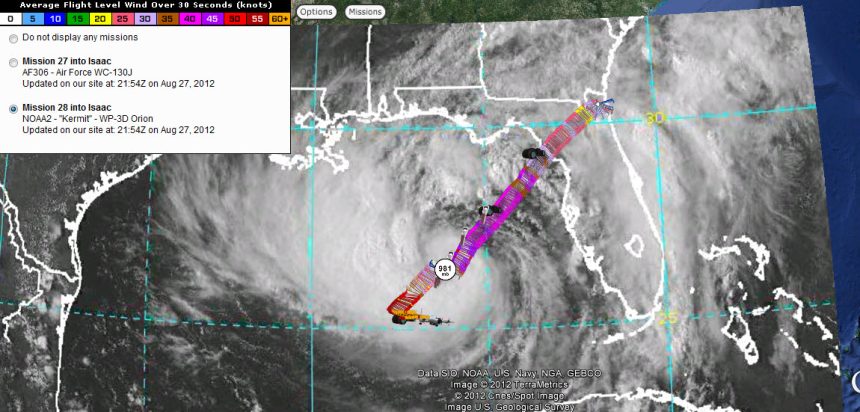
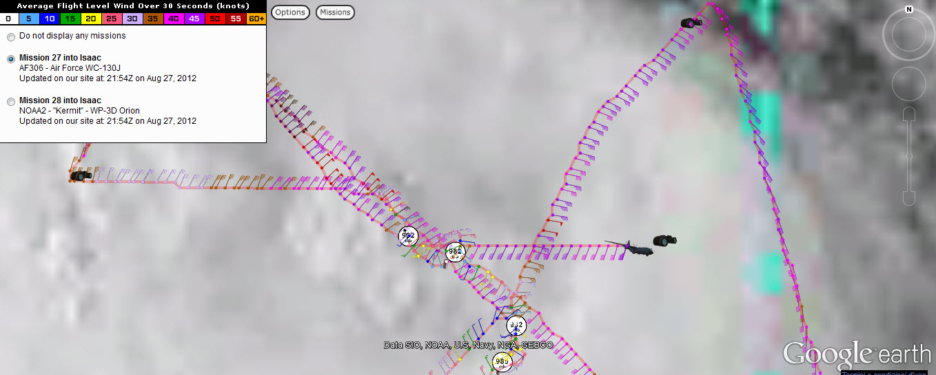
The following data has just been collected by a dropsonde from a WP-3D Orion (N42RF) currently flying over the Gulf of Mexico to analyse “Isaac”.
In other words, this represents the most updated information about the Tropical Storm you can find on the Internet since it is transmitted in real time by the aircraft.
Indeed, thanks to a reader of my site, I’ve found a site that allows you to live track, not only the NOAA flights, but the USAF WC-130J flights too with realtime weather and dropsonde data.
Here’s the site (just refresh it every now and then to get update info): http://tropicalatlantic.com/recon/live/
And here’s the tutorial: http://tropicalatlantic.com/recon/pages/ge_recon_tutorial/
Dropsonde data:
Product: NOAA Temp Drop (Dropsonde) Message (UZNT13 KWBC)
Transmitted: 27th day of the month at 21:43Z
Aircraft: Lockheed WP-3D Orion (Reg. Num. N42RF)
Storm Number: 09
Storm Name: Isaac (flight in the North Atlantic basin)
Mission Number: 28
Observation Number: 07
Part A…
Highest Mandatory Level For Which Wind Was Reported: 850mb
Coordinates: 26.3N 86.3W
Location: 263 miles (423 km) to the WSW (244°) from Tampa, FL, USA.
Marsden Square: 081 (About)
| Level | Geo. Height | Air Temp. | Dew Point | Wind Direction | Wind Speed |
| 985mb (29.09 inHg) | Sea Level (Surface) | 27.4°C (81.3°F) | 26.3°C (79.3°F) | 320° (from the NW) | 26 knots (30 mph) |
| 1000mb | -132m (-433 ft) | This level does not exist in this area of the storm above the surface level. | |||
| 925mb | 560m (1,837 ft) | 24.2°C (75.6°F) | 24.1°C (75.4°F) | 305° (from the NW) | 17 knots (20 mph) |
| 850mb | 1,300m (4,265 ft) | 20.6°C (69.1°F) | 19.6°C (67.3°F) | 290° (from the WNW) | 26 knots (30 mph) |
Information About Radiosonde:
– Launch Time: 21:28Z
– About Sonde: A descending radiosonde tracked automatically by satellite navigation with no solar or infrared correction.
Remarks Section…
Splash Time:21:31ZRelease Location: 26.33N 86.33W
Release Time:21:28:15ZSplash Location: 26.32N 86.31W
Splash Time:21:31:48ZMean Boundary Level Wind (mean wind in the lowest 500 geopotential meters of the sounding):
– Wind Direction: 310° (from the NW)
– Wind Speed: 24 knots (28 mph)Deep Layer Mean Wind (average wind over the depth of the sounding):
– Wind Direction: 295° (from the WNW)
– Wind Speed: 24 knots (28 mph)
– Depth of Sounding: From 751mb to 985mb
Average Wind Over Lowest Available 150 geopotential meters (gpm) of the sounding:
– Lowest 150m: 159 gpm – 9 gpm (522 geo. feet – 30 geo. feet)
– Wind Direction: 320° (from the NW)
– Wind Speed: 27 knots (31 mph)
Sounding Software Version: AEV 07450
Part B: Data For Significant Levels…
| Significant Temperature And Relative Humidity Levels… | ||
| Level | Air Temperature | Dew Point |
| 985mb (Surface) | 27.4°C (81.3°F) | 26.3°C (79.3°F) |
| 850mb | 20.6°C (69.1°F) | 19.6°C (67.3°F) |
| 766mb | 17.4°C (63.3°F) | 16.4°C (61.5°F) |
| 751mb | 15.6°C (60.1°F) | 15.6°C (60.1°F) |
| Significant Wind Levels… | ||
| Level | Wind Direction | Wind Speed |
| 985mb (Surface) | 320° (from the NW) | 26 knots (30 mph) |
| 977mb | 320° (from the NW) | 28 knots (32 mph) |
| 953mb | 305° (from the NW) | 21 knots (24 mph) |
| 940mb | 305° (from the NW) | 23 knots (26 mph) |
| 925mb | 305° (from the NW) | 17 knots (20 mph) |
| 902mb | 295° (from the WNW) | 17 knots (20 mph) |
| 879mb | 295° (from the WNW) | 17 knots (20 mph) |
| 867mb | 300° (from the WNW) | 20 knots (23 mph) |
| 858mb | 280° (from the W) | 25 knots (29 mph) |
| 850mb | 290° (from the WNW) | 26 knots (30 mph) |
| 751mb | 290° (from the WNW) | 23 knots (26 mph) |
Winds at a particular level are peak winds since a dropsonde only records momentary slices of data at each level as it falls through the atmosphere. These winds are not 1 minute sustained. The highest wind observed in the “Significant Wind Levels” section is noted in bold.
Here’s the route currently being flown by the WP-3D:
And here’s the current position of the U.S. Air Force WC-130J:
Related Articles
- Watch NOAA weather reconnaissance planes flying inside Tropical Storm “Isaac” in almost real-time (theaviationist.com)


