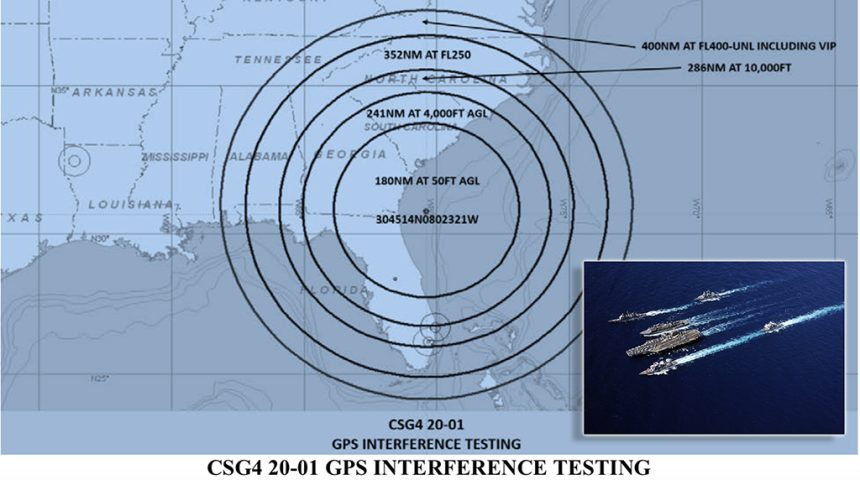
FAA Issues Advisory for Pilots: Large Military GPS Jamming Exercise in Southeast.
The U.S. Federal Aviation Administration (FAA) has issued a flight advisory for January 16-24 warning civilian and commercial pilots that, “GPS testing is scheduled as follows and may result in unreliable or unavailable GPS signal.” The notice is issued under the authority of U.S. Navy Carrier Strike Group 4 (CSG4). The GPS jamming by U.S. Navy Carrier Strike Group Four from Naval Station Norfolk, Virginia, is in support of a large training exercise currently taking place off the U.S. east coast.
The good news for most people in the American southeast is that the vast GPS jamming exercise is unlikely to disrupt civilian and commercial, ground-based GPS such as automobile navigation and fitness users. It is probable that some commercial and civilian air and sea traffic GPS systems will be heavily impacted by the ongoing Carrier Strike Group 4 GPS denial exercise.
Warren Morningstar, the Aircraft Owners and Pilots Association (AOPA) Live Executive Producer said in an internet broadcast on January 14, 2020, that, “Well, here we go again, the United States military could be upsetting your navigation with GPS jamming.” Morningstar went on to say, “If you find that jamming is causing a safety of flight issue, you can tell air traffic control, ‘stop buzzer’, ATC will tell the military to knock it off.”
A Military Times article by Dylan Gresik published January 18, 2020, reported that, “According to the U.S. Coast Guard’s Navigation Center, the federal government ‘is required to conduct GPS tests, training activities, and exercises that involve interfering with GPS receivers.’”
Gresik went also reported that, “In early February 2019, Carrier Strike Group Four conducted similar GPS interference testing in the same area. Through Jan. 30, there are additional flight advisories issued for similar GPS interference testing exercises out of Fort Hood, Texas, Yuma Proving Grounds, Arizona, Cannon Air Force Base, New Mexico, and Fort Bragg, North Carolina.”
As David Cenciotti of TheAviationist.com reported from a similar training exercise in a February 8, 2019 story, “the U.S. military frequently trains to deny or degrade GPS signals on a large-scale. In 2017, we went inside Nellis AFB to get a firsthand demonstration of how easy and how quickly the U.S. Air Force can jam GPS signals for training purposes.”
The GPS jamming going on now in the American southeast is not constant, but an intermittent and potentially partial disruption to Global Positioning System reception in the region.
Specific dates and times for GPS jamming were published by the FAA and Carrier Strike Group 4 and include: Thursday, January 16, 2020 from 1200 Zulu until 2100 Zulu, Friday, January 17, 2020 from 1330 Zulu until 1700 Zulu, Saturday, January 18, 2020 from 1700 Zulu until 2359 Zulu. Then there is a pause in the exercise until jamming resumes on Thursday, January 23, 2020 from 1200 Zulu until 2359 Zulu, Friday, January 24, 2020 from 1200 Zulu until 2359 Zulu and Saturday, January 24, 2020 from 1130 Zulu until 2359 Zulu.
The Global Positioning System provides signals for air traffic control systems such as the Automatic Dependent Surveillance-Broadcast system, or “ADS-B” as it is popularly known in aviation. GPS satellites also provide the Ground Based Augmentation System and the Wide Area Augmentation System.
In the civilian sector, GPS plays a role in everything from banking to telecommunications and weather forecasting in addition to civilian and commercial surface vehicle traffic like passenger cars and commercial ground transportation. Within the last decade, the global GPS system has been characterized by both the United Nations and former U.S. President Barack Obama as “a basic human utility” since it serves not only navigation but essential security, economic and environmental industries and services.
The U.S. Global Positioning System is serviced predominantly by a constellation of up to 32 medium-altitude earth orbit satellites in six different orbital paths moving constantly so that ground and air based GPS receivers can acquire multiple satellites to achieve greater positional accuracy in three dimensions. If you own a fitness GPS watch such as Garmin, Suunto or other brand, you will notice that the more satellite signals your device acquires, the more detailed, accurate and constant your data becomes. Russia, the European Union and China each have launched their own GPS satellite constellations into orbit as a means of maintaining sovereign national control over the valuable GPS signal asset.